Lütian geodata
Lütian (Guangdong) is a seat of a fourth-order administrative division; located in China in Asia/Shanghai (GMT+8) time zone. In our database, there are 1268 cities with bigger population. Compared to other cities in China, 90.9% of cities are located further ↑North; 51.7% of cities are located further →East and 56.3% of cities have lower elevation than Lütian. Note1


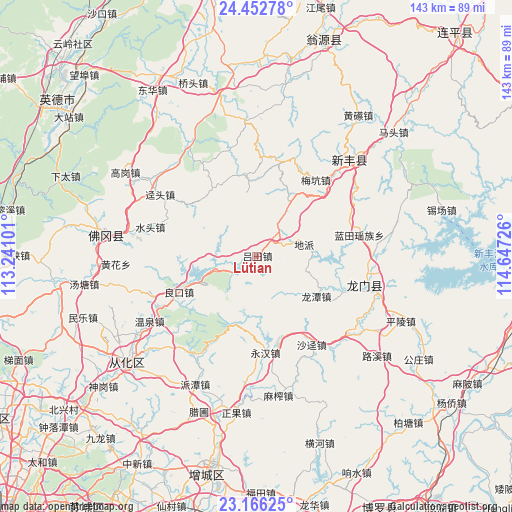
Lütian GPS coordinates[2]
23° 48' 39.996" North, 113° 56' 38.868" East
| Map corner | latitude | longitude |
|---|---|---|
| Upper-left | 24.45278°, | 113.24101° |
| Center: | 23.81111°, | 113.94413° |
| Lower-right: | 23.16625°, | 114.64726° |
| Map W x H: | 143×143.1 km | = 88.9×88.9mi |
| max Lat: | 53.31946° ⇑90.9% North |
| Lütian: | 23.81111° |
| min Lat: | ⇓9.1% South 18.22056° |
| min Long | Lütian | max Long |
| 75.07348° | 113.94413° | 134.28917° |
| W 48.3%⇐ | ⇒51.7% E |
Elevation
Elevation of Lütian is 219 m = 719 ft, and this is 265.8 m = 872 ft below average elevation for this country.
| Max E: |
5622 m = 18445 ft | 43.7% |
| Avg. | 484.8 m = 1591 ft | |
| Lütian | 219 m = 719 ft | |
Min E: |
-3 m = -10 ft | 56.3% |
See also: China elevation on elevation.city.
Geographical zone
Lütian is located in North temperate zone (between Tropic of Cancer and the Arctic Circle). Distance of this Northern Tropic circle is 41.6 km =25.8 mi to South.| Distance of | km | miles | from Lütian |
|---|---|---|---|
| North Pole | 7359.5 | 4573 | to North |
| Arctic Circle | 4753.6 | 2953.7 | to North |
| Tropic Cancer | 41.6 | 25.8 | to South |
| Equator | 2647.5 | 1645.1 | to South |


Nearby cities:
15 places around Lütian: (largest is in red/bold)
• Dipa
14.4 km =8.9 mi,  73°
73°
• Jingtou
32.3 km =20.1 mi,  303°
303°
• Lantian
29.3 km =18.2 mi,  78°
78°
• Liangkou
23.8 km =14.8 mi,  245°
245°
• Longcheng
32.3 km =20.1 mi,  105°
105°
• Longtan
19.8 km =12.3 mi,  123°
123°
• Longtian
31.8 km =19.8 mi,  102°
102°
• Meikeng
27.9 km =17.3 mi,  37°
37°
• Shajing
29 km =18 mi,  147°
147°
• Shatian
19.2 km =11.9 mi,  356°
356°
• Shuitou
30.9 km =19.2 mi,  285°
285°
• Wangping
32.1 km =19.9 mi, 105°
• Xiaozhen
21.1 km =13.1 mi,  23°
23°
• Yaotian
22.6 km =14 mi,  327°
327°
• Yonghan
26.9 km =16.7 mi,  174°
174°
Sources, notices
• [Note1] Compared only with cities in China existing in our database
• [Src1] Map data: © OpenStreetMap contributors (CC-BY-SA)
• [Src2] Other city data from geonames.org with taken over terms of usage.
• [Src3] Geographical zone / Annual Mean Temperature by Robert A. Rohde @ Wikipedia
