Sanxi geodata
Sanxi (Hubei) is a seat of a fourth-order administrative division; located in China in Asia/Shanghai (GMT+8) time zone. In our database, there are 1268 cities with bigger population. Compared to other cities in China, 56% of cities are located further ↑North; 53.9% of cities are located further ←West and 63.5% of cities have higher elevation than Sanxi. Note1


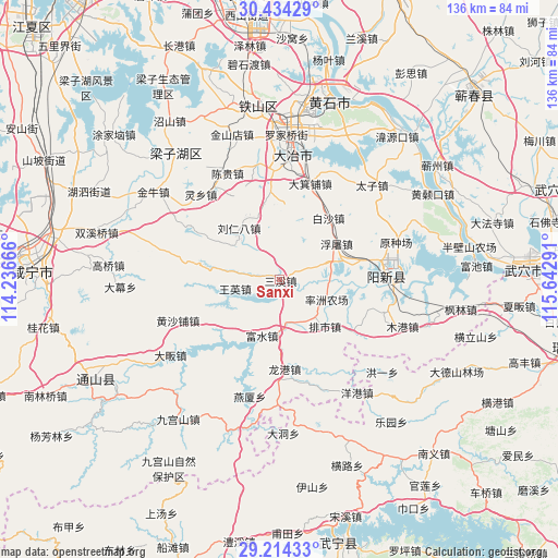
Sanxi GPS coordinates[2]
29° 49' 34.212" North, 114° 56' 23.208" East
| Map corner | latitude | longitude |
|---|---|---|
| Upper-left | 30.43429°, | 114.23666° |
| Center: | 29.82617°, | 114.93978° |
| Lower-right: | 29.21433°, | 115.64291° |
| Map W x H: | 135.6×135.6 km | = 84.3×84.3mi |
| max Lat: | 53.31946° ⇑56% North |
| Sanxi: | 29.82617° |
| min Lat: | ⇓44% South 18.22056° |
| min Long | Sanxi | max Long |
| 75.07348° | 114.93978° | 134.28917° |
| W 53.9%⇐ | ⇒46.1% E |
Elevation
Elevation of Sanxi is 80 m = 262 ft, and this is 404.8 m = 1328 ft below average elevation for this country.
| Max E: |
5622 m = 18445 ft | 63.5% |
| Avg. | 484.8 m = 1591 ft | |
| Sanxi | 80 m = 262 ft | |
Min E: |
-3 m = -10 ft | 36.5% |
See also: China elevation on elevation.city.
Geographical zone
Sanxi is located in North temperate zone (between Tropic of Cancer and the Arctic Circle). Distance of this Northern Tropic circle is 710.4 km =441.4 mi to South.| Distance of | km | miles | from Sanxi |
|---|---|---|---|
| North Pole | 6690.7 | 4157.4 | to North |
| Arctic Circle | 4084.8 | 2538.2 | to North |
| Tropic Cancer | 710.4 | 441.4 | to South |
| Equator | 3316.4 | 2060.7 | to South |


Nearby cities:
15 places around Sanxi: (largest is in red/bold)
• Baisha
19.1 km =11.9 mi,  38°
38°
• Chengui
28.3 km =17.6 mi,  331°
331°
• Cikou
20.7 km =12.9 mi,  222°
222°
• Dajipu
25.3 km =15.7 mi,  16°
16°
• Daye
28.6 km =17.8 mi,  1°
1°
• Futu
16.3 km =10.1 mi,  57°
57°
• Huangshapu
26.8 km =16.7 mi,  249°
249°
• Liurenba
16.3 km =10.1 mi,  319°
319°
• Longgang
22.3 km =13.9 mi,  177°
177°
• Majiao
26.4 km =16.4 mi,  357°
357°
• Paishi
16 km =9.9 mi,  136°
136°
• Ruanyitu
26.5 km =16.5 mi,  65°
65°
• Wangying
11 km =6.8 mi,  257°
257°
• Xingguo
25.9 km =16.1 mi,  88°
88°
• Yinzu
15.8 km =9.8 mi,  341°
341°
Sources, notices
• [Note1] Compared only with cities in China existing in our database
• [Src1] Map data: © OpenStreetMap contributors (CC-BY-SA)
• [Src2] Other city data from geonames.org with taken over terms of usage.
• [Src3] Geographical zone / Annual Mean Temperature by Robert A. Rohde @ Wikipedia
