Paishi geodata
Paishi (Hubei) is a seat of a fourth-order administrative division; located in China in Asia/Shanghai (GMT+8) time zone. In our database, there are 1268 cities with bigger population. Compared to other cities in China, 57.2% of cities are located further ↑North; 54.6% of cities are located further ←West and 75.3% of cities have higher elevation than Paishi. Note1


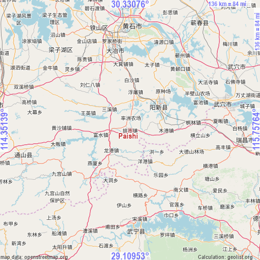
Paishi GPS coordinates[2]
29° 43' 19.2" North, 115° 3' 16.236" East
| Map corner | latitude | longitude |
|---|---|---|
| Upper-left | 30.33076°, | 114.35139° |
| Center: | 29.722°, | 115.05451° |
| Lower-right: | 29.10953°, | 115.75764° |
| Map W x H: | 135.8×135.8 km | = 84.4×84.4mi |
| max Lat: | 53.31946° ⇑57.2% North |
| Paishi: | 29.722° |
| min Lat: | ⇓42.8% South 18.22056° |
| min Long | Paishi | max Long |
| 75.07348° | 115.05451° | 134.28917° |
| W 54.6%⇐ | ⇒45.4% E |
Elevation
Elevation of Paishi is 36 m = 118 ft, and this is 448.8 m = 1472 ft below average elevation for this country.
| Max E: |
5622 m = 18445 ft | 75.3% |
| Avg. | 484.8 m = 1591 ft | |
| Paishi | 36 m = 118 ft | |
Min E: |
-3 m = -10 ft | 24.7% |
See also: China elevation on elevation.city.
Geographical zone
Paishi is located in North temperate zone (between Tropic of Cancer and the Arctic Circle). Distance of this Northern Tropic circle is 698.9 km =434.3 mi to South.| Distance of | km | miles | from Paishi |
|---|---|---|---|
| North Pole | 6702.3 | 4164.6 | to North |
| Arctic Circle | 4096.4 | 2545.4 | to North |
| Tropic Cancer | 698.9 | 434.3 | to South |
| Equator | 3304.8 | 2053.5 | to South |


Nearby cities:
15 places around Paishi: (largest is in red/bold)
• Baisha
26.4 km =16.4 mi,  2°
2°
• Cikou
25.4 km =15.8 mi,  261°
261°
• Dadong
27.9 km =17.3 mi,  201°
201°
• Futu
20.5 km =12.7 mi,  7°
7°
• Hongyi
17.7 km =11 mi,  128°
128°
• Longgang
14.7 km =9.1 mi,  223°
223°
• Mugang
18.5 km =11.5 mi,  89°
89°
• Quankou
25 km =15.5 mi,  185°
185°
• Ruanyitu
26.2 km =16.3 mi,  29°
29°
• Sanxi
16 km =9.9 mi,  316°
316°
• Wangying
23.6 km =14.7 mi,  292°
292°
• Xingguo
19.4 km =12.1 mi,  50°
50°
• Yanggang
17.9 km =11.1 mi,  153°
153°
• Yanxia
25.1 km =15.6 mi,  227°
227°
• Zhaochen
20.1 km =12.5 mi,  140°
140°
Sources, notices
• [Note1] Compared only with cities in China existing in our database
• [Src1] Map data: © OpenStreetMap contributors (CC-BY-SA)
• [Src2] Other city data from geonames.org with taken over terms of usage.
• [Src3] Geographical zone / Annual Mean Temperature by Robert A. Rohde @ Wikipedia
