Sansha geodata
Sansha (Fujian) is a seat of a fourth-order administrative division; located in China in Asia/Shanghai (GMT+8) time zone. In our database, there are 1268 cities with bigger population. Compared to other cities in China, 78.9% of cities are located further ↑North; 83.2% of cities are located further ←West and 73.3% of cities have higher elevation than Sansha. Note1


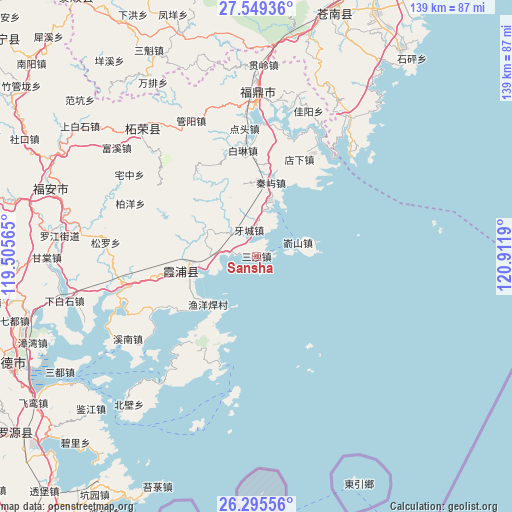
Sansha GPS coordinates[2]
26° 55' 27.12" North, 120° 12' 31.572" East
| Map corner | latitude | longitude |
|---|---|---|
| Upper-left | 27.54936°, | 119.50565° |
| Center: | 26.9242°, | 120.20877° |
| Lower-right: | 26.29556°, | 120.9119° |
| Map W x H: | 139.4×139.4 km | = 86.6×86.6mi |
| max Lat: | 53.31946° ⇑78.9% North |
| Sansha: | 26.9242° |
| min Lat: | ⇓21.1% South 18.22056° |
| min Long | Sansha | max Long |
| 75.07348° | 120.20877° | 134.28917° |
| W 83.2%⇐ | ⇒16.8% E |
Elevation
Elevation of Sansha is 41 m = 135 ft, and this is 443.8 m = 1456 ft below average elevation for this country.
| Max E: |
5622 m = 18445 ft | 73.3% |
| Avg. | 484.8 m = 1591 ft | |
| Sansha | 41 m = 135 ft | |
Min E: |
-3 m = -10 ft | 26.7% |
See also: China elevation on elevation.city.
Geographical zone
Sansha is located in North temperate zone (between Tropic of Cancer and the Arctic Circle). Distance of this Northern Tropic circle is 387.8 km =241 mi to South.| Distance of | km | miles | from Sansha |
|---|---|---|---|
| North Pole | 7013.4 | 4357.9 | to North |
| Arctic Circle | 4407.5 | 2738.7 | to North |
| Tropic Cancer | 387.8 | 241 | to South |
| Equator | 2993.7 | 1860.2 | to South |


Nearby cities:
15 places around Sansha: (largest is in red/bold)
• Baiyang
37.2 km =23.1 mi,  292°
292°
• Changchun
27.4 km =17 mi,  217°
217°
• Chongru
28.3 km =17.6 mi,  276°
276°
• Dongyuan
44.6 km =27.7 mi,  316°
316°
• Fuding
44.8 km =27.8 mi,  0°
0°
• Shajiang
28.7 km =17.8 mi,  236°
236°
• Shuimen
14.8 km =9.2 mi, 290°
• Songcheng
21.1 km =13.1 mi,  257°
257°
• Xiahu
43.4 km =27 mi, 216°
• Xinan
41.8 km =26 mi, 237°
• Yacheng
7.4 km =4.6 mi,  344°
344°
• Yantian
35.7 km =22.2 mi, 257°
• Yushan
11.9 km =7.4 mi,  71°
71°
• Zhaizhong
41.1 km =25.5 mi,  302°
302°
• Zhayang
41.8 km =26 mi,  326°
326°
Sources, notices
• [Note1] Compared only with cities in China existing in our database
• [Src1] Map data: © OpenStreetMap contributors (CC-BY-SA)
• [Src2] Other city data from geonames.org with taken over terms of usage.
• [Src3] Geographical zone / Annual Mean Temperature by Robert A. Rohde @ Wikipedia
