Longsheng geodata
Longsheng (Guangdong) is a seat of a fourth-order administrative division; located in China in Asia/Shanghai (GMT+8) time zone. In our database, there are 1268 cities with bigger population. Compared to other cities in China, 96.2% of cities are located further ↑North; 60.2% of cities are located further →East and 83.9% of cities have higher elevation than Longsheng. Note1


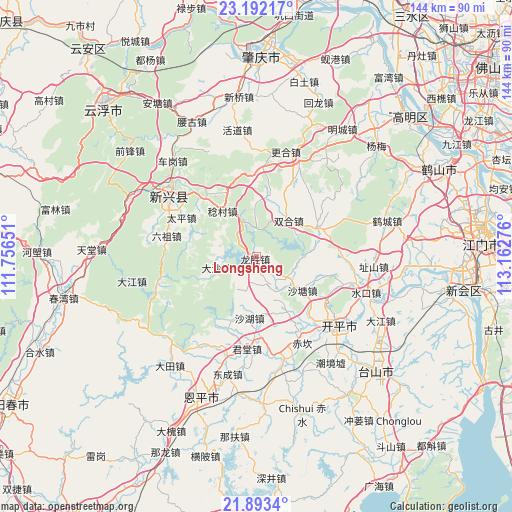
Longsheng GPS coordinates[2]
22° 32' 39.516" North, 112° 27' 34.668" East
| Map corner | latitude | longitude |
|---|---|---|
| Upper-left | 23.19217°, | 111.75651° |
| Center: | 22.54431°, | 112.45963° |
| Lower-right: | 21.8934°, | 113.16276° |
| Map W x H: | 144.4×144.4 km | = 89.7×89.7mi |
| max Lat: | 53.31946° ⇑96.2% North |
| Longsheng: | 22.54431° |
| min Lat: | ⇓3.8% South 18.22056° |
| min Long | Longsheng | max Long |
| 75.07348° | 112.45963° | 134.28917° |
| W 39.8%⇐ | ⇒60.2% E |
Elevation
Elevation of Longsheng is 18 m = 59 ft, and this is 466.8 m = 1531 ft below average elevation for this country.
| Max E: |
5622 m = 18445 ft | 83.9% |
| Avg. | 484.8 m = 1591 ft | |
| Longsheng | 18 m = 59 ft | |
Min E: |
-3 m = -10 ft | 16.1% |
See also: China elevation on elevation.city.
Geographical zone
Longsheng is located in North Torrid zone (between Equator and Tropic of Cancer). Distance of this Northern Tropic circle is 99.2 km =61.6 mi to North.| Distance of | km | miles | from Longsheng |
|---|---|---|---|
| North Pole | 7500.4 | 4660.5 | to North |
| Arctic Circle | 4894.5 | 3041.3 | to North |
| Tropic Cancer | 99.2 | 61.6 | to North |
| Equator | 2506.7 | 1557.6 | to South |


Nearby cities:
15 places around Longsheng: (largest is in red/bold)
• Cangcheng
11.7 km =7.3 mi,  129°
129°
• Chikan
27.6 km =17.1 mi,  153°
153°
• Dasha
12.1 km =7.5 mi,  257°
257°
• Dongcheng
21.4 km =13.3 mi,  317°
317°
• Juntang
25.3 km =15.7 mi,  188°
188°
• Liuzu
25.9 km =16.1 mi,  283°
283°
• Magang
8.2 km =5.1 mi,  155°
155°
• Niujiang
20.4 km =12.7 mi,  203°
203°
• Rencun
16 km =9.9 mi, 323°
• Shahu
17.3 km =10.7 mi, 186°
• Shatang
16.2 km =10.1 mi, 126°
• Shuitai
8.4 km =5.2 mi,  5°
5°
• Taiping
25.2 km =15.7 mi,  295°
295°
• Tangkou
25.4 km =15.8 mi,  140°
140°
• Zhaiwu
19.2 km =11.9 mi,  64°
64°
Sources, notices
• [Note1] Compared only with cities in China existing in our database
• [Src1] Map data: © OpenStreetMap contributors (CC-BY-SA)
• [Src2] Other city data from geonames.org with taken over terms of usage.
• [Src3] Geographical zone / Annual Mean Temperature by Robert A. Rohde @ Wikipedia
