Qushui geodata
Qushui (Chongqing) is a seat of a fourth-order administrative division; located in China in Asia/Shanghai (GMT+8) time zone. In our database, there are 1268 cities with bigger population. Compared to other cities in China, 52% of cities are located further ↓South; 80.5% of cities are located further →East and 62.9% of cities have lower elevation than Qushui. Note1


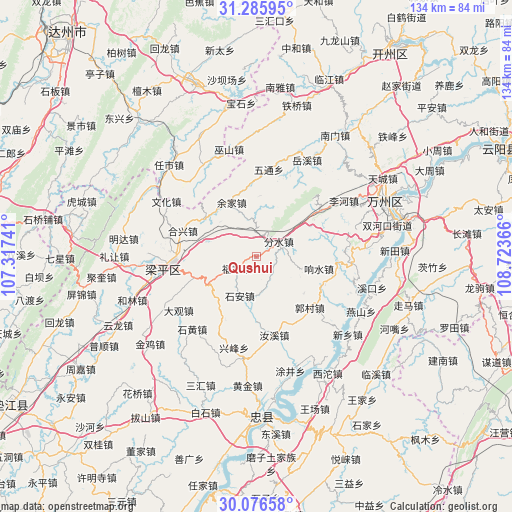
Qushui GPS coordinates[2]
30° 40' 59.376" North, 108° 1' 13.908" East
| Map corner | latitude | longitude |
|---|---|---|
| Upper-left | 31.28595°, | 107.31741° |
| Center: | 30.68316°, | 108.02053° |
| Lower-right: | 30.07658°, | 108.72366° |
| Map W x H: | 134.5×134.5 km | = 83.6×83.6mi |
| max Lat: | 53.31946° ⇑48% North |
| Qushui: | 30.68316° |
| min Lat: | ⇓52% South 18.22056° |
| min Long | Qushui | max Long |
| 75.07348° | 108.02053° | 134.28917° |
| W 19.5%⇐ | ⇒80.5% E |
Elevation
Elevation of Qushui is 295 m = 968 ft, and this is 189.8 m = 623 ft below average elevation for this country.
| Max E: |
5622 m = 18445 ft | 37.1% |
| Avg. | 484.8 m = 1591 ft | |
| Qushui | 295 m = 968 ft | |
Min E: |
-3 m = -10 ft | 62.9% |
See also: China elevation on elevation.city.
Geographical zone
Qushui is located in North temperate zone (between Tropic of Cancer and the Arctic Circle). Distance of this Northern Tropic circle is 805.7 km =500.6 mi to South.| Distance of | km | miles | from Qushui |
|---|---|---|---|
| North Pole | 6595.4 | 4098.2 | to North |
| Arctic Circle | 3989.5 | 2479 | to North |
| Tropic Cancer | 805.7 | 500.6 | to South |
| Equator | 3411.6 | 2119.9 | to South |


Nearby cities:
15 places around Qushui: (largest is in red/bold)
• Baijia
15 km =9.3 mi,  228°
228°
• Chengdong
13 km =8.1 mi,  288°
288°
• Fenshui
7.2 km =4.5 mi,  55°
55°
• Fulu
5.9 km =3.7 mi,  237°
237°
• Guocun
19.3 km =12 mi,  132°
132°
• Houshan
15.9 km =9.9 mi,  2°
2°
• Jinsheng
17.8 km =11.1 mi,  189°
189°
• Panlong
17.1 km =10.6 mi,  251°
251°
• Shi’an
11.2 km =7 mi,  202°
202°
• Sunjia
5.2 km =3.2 mi,  352°
352°
• Xiangshui
16.8 km =10.4 mi,  100°
100°
• Xiaping
16.7 km =10.4 mi,  306°
306°
• Yehe
19.1 km =11.9 mi,  148°
148°
• Yujia
15.6 km =9.7 mi,  335°
335°
• Zizhao
18.5 km =11.5 mi,  205°
205°
Sources, notices
• [Note1] Compared only with cities in China existing in our database
• [Src1] Map data: © OpenStreetMap contributors (CC-BY-SA)
• [Src2] Other city data from geonames.org with taken over terms of usage.
• [Src3] Geographical zone / Annual Mean Temperature by Robert A. Rohde @ Wikipedia
