Yujia geodata
Yujia (Chongqing) is a seat of a fourth-order administrative division; located in China in Asia/Shanghai (GMT+8) time zone. In our database, there are 1268 cities with bigger population. Compared to other cities in China, 53% of cities are located further ↓South; 80.7% of cities are located further →East and 64.5% of cities have lower elevation than Yujia. Note1


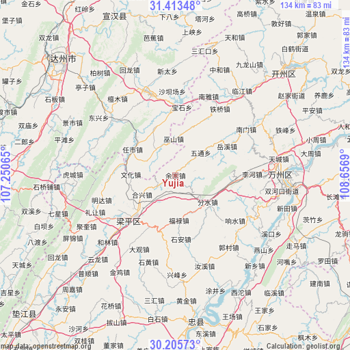
Yujia GPS coordinates[2]
30° 48' 41.4" North, 107° 57' 13.572" East
| Map corner | latitude | longitude |
|---|---|---|
| Upper-left | 31.41348°, | 107.25065° |
| Center: | 30.8115°, | 107.95377° |
| Lower-right: | 30.20573°, | 108.6569° |
| Map W x H: | 134.3×134.3 km | = 83.5×83.5mi |
| max Lat: | 53.31946° ⇑47% North |
| Yujia: | 30.8115° |
| min Lat: | ⇓53% South 18.22056° |
| min Long | Yujia | max Long |
| 75.07348° | 107.95377° | 134.28917° |
| W 19.3%⇐ | ⇒80.7% E |
Elevation
Elevation of Yujia is 317 m = 1040 ft, and this is 167.8 m = 551 ft below average elevation for this country.
| Max E: |
5622 m = 18445 ft | 35.5% |
| Avg. | 484.8 m = 1591 ft | |
| Yujia | 317 m = 1040 ft | |
Min E: |
-3 m = -10 ft | 64.5% |
See also: China elevation on elevation.city.
Geographical zone
Yujia is located in North temperate zone (between Tropic of Cancer and the Arctic Circle). Distance of this Northern Tropic circle is 820 km =509.5 mi to South.| Distance of | km | miles | from Yujia |
|---|---|---|---|
| North Pole | 6581.1 | 4089.3 | to North |
| Arctic Circle | 3975.3 | 2470.1 | to North |
| Tropic Cancer | 820 | 509.5 | to South |
| Equator | 3425.9 | 2128.8 | to South |


Nearby cities:
15 places around Yujia: (largest is in red/bold)
• Chengbei
19 km =11.8 mi,  238°
238°
• Chengdong
11.8 km =7.3 mi,  210°
210°
• Danzi
7.1 km =4.4 mi,  44°
44°
• Fenshui
16 km =9.9 mi,  129°
129°
• Fulu
17.5 km =10.9 mi,  175°
175°
• Hexing
14.8 km =9.2 mi, 239°
• Houshan
7.3 km =4.5 mi,  77°
77°
• Panlong
22 km =13.7 mi, 206°
• Qushui
15.6 km =9.7 mi,  155°
155°
• Sunjia
10.7 km =6.6 mi,  147°
147°
• Wenhua
17.1 km =10.6 mi,  271°
271°
• Wushan
14 km =8.7 mi,  357°
357°
• Wutong
13.1 km =8.1 mi,  48°
48°
• Xiaping
8.3 km =5.2 mi, 238°
• Xinsheng
22.2 km =13.8 mi,  279°
279°
Sources, notices
• [Note1] Compared only with cities in China existing in our database
• [Src1] Map data: © OpenStreetMap contributors (CC-BY-SA)
• [Src2] Other city data from geonames.org with taken over terms of usage.
• [Src3] Geographical zone / Annual Mean Temperature by Robert A. Rohde @ Wikipedia
