Qingyuan geodata
Qingyuan (Shanxi) is a seat of a third-order administrative division; located in China in Asia/Shanghai (GMT+8) time zone. In our database, there are 1268 cities with bigger population. Compared to other cities in China, 80.5% of cities are located further ↓South; 61% of cities are located further →East and 81.9% of cities have lower elevation than Qingyuan. Note1


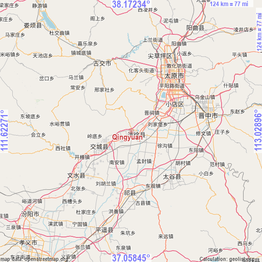
Qingyuan GPS coordinates[2]
37° 37' 2.928" North, 112° 19' 32.988" East
| Map corner | latitude | longitude |
|---|---|---|
| Upper-left | 38.17234°, | 111.62271° |
| Center: | 37.61748°, | 112.32583° |
| Lower-right: | 37.05845°, | 113.02896° |
| Map W x H: | 123.9×123.9 km | = 77×77mi |
| max Lat: | 53.31946° ⇑19.5% North |
| Qingyuan: | 37.61748° |
| min Lat: | ⇓80.5% South 18.22056° |
| min Long | Qingyuan | max Long |
| 75.07348° | 112.32583° | 134.28917° |
| W 39%⇐ | ⇒61% E |
Elevation
Elevation of Qingyuan is 784 m = 2572 ft, and this is 299.2 m = 982 ft above average elevation for this country.
| Max E: |
5622 m = 18445 ft | 18.1% |
| Qingyuan | 784 m 2572 ft | |
| Avg. | 484.8 m = 1591 ft | |
Min E: |
-3 m = -10 ft | 81.9% |
See also: China elevation on elevation.city.
Geographical zone
Qingyuan is located in North temperate zone (between Tropic of Cancer and the Arctic Circle). Distance of this Northern Tropic circle is 1576.8 km =979.8 mi to South.| Distance of | km | miles | from Qingyuan |
|---|---|---|---|
| North Pole | 5824.4 | 3619.1 | to North |
| Arctic Circle | 3218.5 | 1999.9 | to North |
| Tropic Cancer | 1576.8 | 979.8 | to South |
| Equator | 4182.7 | 2599 | to South |


Nearby cities:
15 places around Qingyuan: (largest is in red/bold)
• Chaicun
37.5 km =23.3 mi,  20°
20°
• Changning
46.1 km =28.6 mi,  85°
85°
• Dongqu
35.4 km =22 mi,  341°
341°
• Dongzhao
46.8 km =29.1 mi,  79°
79°
• Fengcheng
33.7 km =20.9 mi,  232°
232°
• Jinyuan
17.6 km =10.9 mi,  46°
46°
• Julun
38.1 km =23.7 mi,  32°
32°
• Liuxiang
35 km =21.7 mi,  36°
36°
• Mingxing
28.7 km =17.8 mi,  137°
137°
• Qianfeng
31 km =19.3 mi, 33°
• Taiyuan
34.8 km =21.6 mi, 36°
• Tianning
16.5 km =10.3 mi,  241°
241°
• Xiaodian
24.2 km =15 mi,  56°
56°
• Yuci
36.4 km =22.6 mi, 78°
• Zhaoyu
29.2 km =18.1 mi,  181°
181°
In other languages:
- In Chinese: Ch’ing-hsü, Ch’ing-hsü-hsien, Ch’ing-yüan, T’sinyuan’, Ch’ing-yüan-hsien, Ch’ing-yüan-ch’eng, 清源, Tsingyüanhsien, Sükowhsien
Sources, notices
• [Note1] Compared only with cities in China existing in our database
• [Src1] Map data: © OpenStreetMap contributors (CC-BY-SA)
• [Src2] Other city data from geonames.org with taken over terms of usage.
• [Src3] Geographical zone / Annual Mean Temperature by Robert A. Rohde @ Wikipedia
