Fengcheng geodata
Fengcheng (Shanxi) is a seat of a third-order administrative division; located in China in Asia/Shanghai (GMT+8) time zone. In our database, there are 1268 cities with bigger population. Compared to other cities in China, 80.1% of cities are located further ↓South; 62.6% of cities are located further →East and 81.4% of cities have lower elevation than Fengcheng. Note1


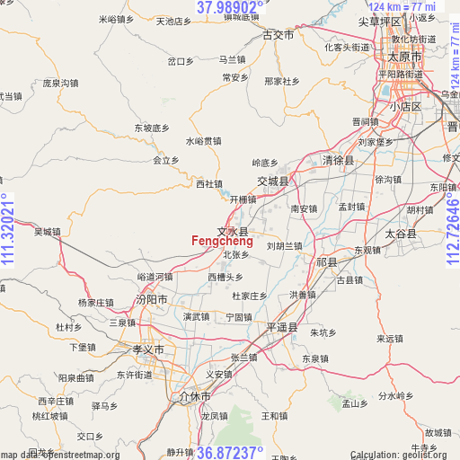
Fengcheng GPS coordinates[2]
37° 25' 58.008" North, 112° 1' 23.988" East
| Map corner | latitude | longitude |
|---|---|---|
| Upper-left | 37.98902°, | 111.32021° |
| Center: | 37.43278°, | 112.02333° |
| Lower-right: | 36.87237°, | 112.72646° |
| Map W x H: | 124.2×124.2 km | = 77.2×77.2mi |
| max Lat: | 53.31946° ⇑19.9% North |
| Fengcheng: | 37.43278° |
| min Lat: | ⇓80.1% South 18.22056° |
| min Long | Fengcheng | max Long |
| 75.07348° | 112.02333° | 134.28917° |
| W 37.4%⇐ | ⇒62.6% E |
Elevation
Elevation of Fengcheng is 760 m = 2493 ft, and this is 275.2 m = 903 ft above average elevation for this country.
| Max E: |
5622 m = 18445 ft | 18.6% |
| Fengcheng | 760 m 2493 ft | |
| Avg. | 484.8 m = 1591 ft | |
Min E: |
-3 m = -10 ft | 81.4% |
See also: China elevation on elevation.city.
Geographical zone
Fengcheng is located in North temperate zone (between Tropic of Cancer and the Arctic Circle). Distance of this Northern Tropic circle is 1556.2 km =967 mi to South.| Distance of | km | miles | from Fengcheng |
|---|---|---|---|
| North Pole | 5844.9 | 3631.9 | to North |
| Arctic Circle | 3239 | 2012.6 | to North |
| Tropic Cancer | 1556.2 | 967 | to South |
| Equator | 4162.1 | 2586.2 | to South |


Nearby cities:
15 places around Fengcheng: (largest is in red/bold)
• Chaicun
68.4 km =42.5 mi,  35°
35°
• Cuifeng
68.8 km =42.8 mi,  198°
198°
• Dongqu
56.4 km =35 mi,  16°
16°
• Gutao
29 km =18 mi,  151°
151°
• Jiexiu
46.5 km =28.9 mi,  192°
192°
• Jinyuan
51.2 km =31.8 mi,  50°
50°
• Liuxiang
67.9 km =42.2 mi, 44°
• Mingxing
46 km =28.6 mi,  90°
90°
• Qianfeng
63.8 km =39.6 mi, 43°
• Qingyuan
33.7 km =20.9 mi, 52°
• Taiyuan
67.8 km =42.1 mi, 44°
• Tianning
17.6 km =10.9 mi, 43°
• Xiaodian
57.8 km =35.9 mi, 54°
• Yuci
68.3 km =42.4 mi,  66°
66°
• Zhaoyu
27.3 km =17 mi,  108°
108°
Sources, notices
• [Note1] Compared only with cities in China existing in our database
• [Src1] Map data: © OpenStreetMap contributors (CC-BY-SA)
• [Src2] Other city data from geonames.org with taken over terms of usage.
• [Src3] Geographical zone / Annual Mean Temperature by Robert A. Rohde @ Wikipedia
