Chaicun geodata
Chaicun (Shanxi) is a seat of a third-order administrative division; located in China in Asia/Shanghai (GMT+8) time zone. In our database, there are 1268 cities with bigger population. Compared to other cities in China, 80.8% of cities are located further ↓South; 60.2% of cities are located further →East and 82.8% of cities have lower elevation than Chaicun. Note1


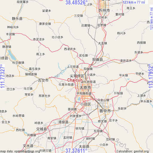
Chaicun GPS coordinates[2]
37° 55' 58.008" North, 112° 28' 35.004" East
| Map corner | latitude | longitude |
|---|---|---|
| Upper-left | 38.48526°, | 111.77327° |
| Center: | 37.93278°, | 112.47639° |
| Lower-right: | 37.37611°, | 113.17952° |
| Map W x H: | 123.3×123.3 km | = 76.6×76.6mi |
| max Lat: | 53.31946° ⇑19.2% North |
| Chaicun: | 37.93278° |
| min Lat: | ⇓80.8% South 18.22056° |
| min Long | Chaicun | max Long |
| 75.07348° | 112.47639° | 134.28917° |
| W 39.8%⇐ | ⇒60.2% E |
Elevation
Elevation of Chaicun is 834 m = 2736 ft, and this is 349.2 m = 1146 ft above average elevation for this country.
| Max E: |
5622 m = 18445 ft | 17.2% |
| Chaicun | 834 m 2736 ft | |
| Avg. | 484.8 m = 1591 ft | |
Min E: |
-3 m = -10 ft | 82.8% |
See also: China elevation on elevation.city.
Geographical zone
Chaicun is located in North temperate zone (between Tropic of Cancer and the Arctic Circle). Distance of this Northern Tropic circle is 1611.8 km =1001.5 mi to South.| Distance of | km | miles | from Chaicun |
|---|---|---|---|
| North Pole | 5789.3 | 3597.3 | to North |
| Arctic Circle | 3183.4 | 1978.1 | to North |
| Tropic Cancer | 1611.8 | 1001.5 | to South |
| Equator | 4217.7 | 2620.8 | to South |


Nearby cities:
15 places around Chaicun: (largest is in red/bold)
• Changning
45 km =28 mi,  133°
133°
• Dongqu
24.3 km =15.1 mi,  266°
266°
• Dongzhao
42.1 km =26.2 mi, 129°
• Huangzhai
22.5 km =14 mi,  45°
45°
• Jinyuan
22.9 km =14.2 mi,  181°
181°
• Julun
7.7 km =4.8 mi,  111°
111°
• Liuxiang
10.1 km =6.3 mi, 132°
• Mingxing
56.6 km =35.2 mi,  173°
173°
• Qianfeng
10.1 km =6.3 mi,  157°
157°
• Qingyuan
37.5 km =23.3 mi,  200°
200°
• Taiyuan
10.2 km =6.3 mi, 133°
• Tianning
51.1 km =31.8 mi,  212°
212°
• Xiaodian
22.9 km =14.2 mi, 162°
• Xinzhou
57.5 km =35.7 mi,  22°
22°
• Yuci
35.9 km =22.3 mi,  141°
141°
Sources, notices
• [Note1] Compared only with cities in China existing in our database
• [Src1] Map data: © OpenStreetMap contributors (CC-BY-SA)
• [Src2] Other city data from geonames.org with taken over terms of usage.
• [Src3] Geographical zone / Annual Mean Temperature by Robert A. Rohde @ Wikipedia
