Qingquan geodata
Qingquan (Hubei) is a seat of a third-order administrative division; located in China in Asia/Shanghai (GMT+8) time zone. With population of 76,154 people, there are 563 cities with bigger population in this country. Compared to other cities in China, 50% of cities are located further ↓South; 55.6% of cities are located further ←West and 75.7% of cities have higher elevation than Qingquan. Note1


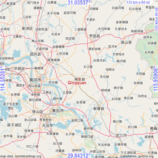
Qingquan GPS coordinates[2]
30° 27' 4.068" North, 115° 15' 21.348" East
| Map corner | latitude | longitude |
|---|---|---|
| Upper-left | 31.05537°, | 114.55281° |
| Center: | 30.45113°, | 115.25593° |
| Lower-right: | 29.84312°, | 115.95906° |
| Map W x H: | 134.8×134.8 km | = 83.8×83.8mi |
| max Lat: | 53.31946° ⇑50% North |
| Qingquan: | 30.45113° |
| min Lat: | ⇓50% South 18.22056° |
| min Long | Qingquan | max Long |
| 75.07348° | 115.25593° | 134.28917° |
| W 55.6%⇐ | ⇒44.4% E |
Elevation
Elevation of Qingquan is 35 m = 115 ft, and this is 449.8 m = 1476 ft below average elevation for this country.
| Max E: |
5622 m = 18445 ft | 75.7% |
| Avg. | 484.8 m = 1591 ft | |
| Qingquan | 35 m = 115 ft | |
Min E: |
-3 m = -10 ft | 24.3% |
See also: Qingquan elevation on elevation.city.
Geographical zone
Qingquan is located in North temperate zone (between Tropic of Cancer and the Arctic Circle). Distance of this Northern Tropic circle is 779.9 km =484.6 mi to South.| Distance of | km | miles | from Qingquan |
|---|---|---|---|
| North Pole | 6621.2 | 4114.2 | to North |
| Arctic Circle | 4015.3 | 2495 | to North |
| Tropic Cancer | 779.9 | 484.6 | to South |
| Equator | 3385.8 | 2103.8 | to South |


Nearby cities:
15 places around Qingquan: (largest is in red/bold)
• Bahe
22.5 km =14 mi,  263°
263°
• Bailian
24 km =14.9 mi,  48°
48°
• Bailianhe
23.8 km =14.8 mi, 46°
• Caihe
19.2 km =11.9 mi, 48°
• Guankou
13.3 km =8.3 mi,  34°
34°
• Hengche
19.1 km =11.9 mi,  146°
146°
• Lanxi
15.9 km =9.9 mi,  223°
223°
• Liulin
22.8 km =14.2 mi,  207°
207°
• Pengsi
19.9 km =12.4 mi,  175°
175°
• Wanggang
20.7 km =12.9 mi,  337°
337°
• Xima
21 km =13 mi,  84°
84°
• Yangye
23.7 km =14.7 mi,  230°
230°
• Yanji
24.4 km =15.2 mi, 256°
• Zhulin
24.4 km =15.2 mi,  111°
111°
• Zhuwa
20.8 km =12.9 mi,  320°
320°
Sources, notices
• [Note1] Compared only with cities in China existing in our database
• [Src1] Map data: © OpenStreetMap contributors (CC-BY-SA)
• [Src2] Other city data from geonames.org with taken over terms of usage.
• [Src3] Geographical zone / Annual Mean Temperature by Robert A. Rohde @ Wikipedia
