Hengche geodata
Hengche (Hubei) is a seat of a fourth-order administrative division; located in China in Asia/Shanghai (GMT+8) time zone. In our database, there are 1268 cities with bigger population. Compared to other cities in China, 51.1% of cities are located further ↑North; 56.2% of cities are located further ←West and 77.7% of cities have higher elevation than Hengche. Note1


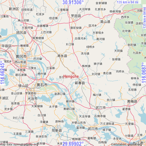
Hengche GPS coordinates[2]
30° 18' 28.512" North, 115° 21' 56.052" East
| Map corner | latitude | longitude |
|---|---|---|
| Upper-left | 30.91306°, | 114.66245° |
| Center: | 30.30792°, | 115.36557° |
| Lower-right: | 29.69902°, | 116.0687° |
| Map W x H: | 135×135 km | = 83.9×83.9mi |
| max Lat: | 53.31946° ⇑51.1% North |
| Hengche: | 30.30792° |
| min Lat: | ⇓48.9% South 18.22056° |
| min Long | Hengche | max Long |
| 75.07348° | 115.36557° | 134.28917° |
| W 56.2%⇐ | ⇒43.8% E |
Elevation
Elevation of Hengche is 31 m = 102 ft, and this is 453.8 m = 1489 ft below average elevation for this country.
| Max E: |
5622 m = 18445 ft | 77.7% |
| Avg. | 484.8 m = 1591 ft | |
| Hengche | 31 m = 102 ft | |
Min E: |
-3 m = -10 ft | 22.3% |
See also: China elevation on elevation.city.
Geographical zone
Hengche is located in North temperate zone (between Tropic of Cancer and the Arctic Circle). Distance of this Northern Tropic circle is 764 km =474.7 mi to South.| Distance of | km | miles | from Hengche |
|---|---|---|---|
| North Pole | 6637.1 | 4124.1 | to North |
| Arctic Circle | 4031.2 | 2504.9 | to North |
| Tropic Cancer | 764 | 474.7 | to South |
| Equator | 3369.9 | 2094 | to South |


Nearby cities:
15 places around Hengche: (largest is in red/bold)
• Caohe
10.9 km =6.8 mi,  143°
143°
• Guanyao
19.4 km =12.1 mi,  205°
205°
• Hekou
22.4 km =13.9 mi,  218°
218°
• Lanxi
21.9 km =13.6 mi,  281°
281°
• Liuhe
20.4 km =12.7 mi,  92°
92°
• Liulin
21.5 km =13.4 mi,  258°
258°
• Pengsi
9.8 km =6.1 mi,  246°
246°
• Qingquan
19.1 km =11.9 mi,  326°
326°
• Sanhua
25.7 km =16 mi, 253°
• Shizi
24.5 km =15.2 mi,  68°
68°
• Weiyuankou
23.2 km =14.4 mi, 213°
• Xima
20.9 km =13 mi,  29°
29°
• Xisaishan
21.8 km =13.5 mi,  240°
240°
• Zhulin
13.9 km =8.6 mi,  60°
60°
• Zoumaling
12.1 km =7.5 mi,  151°
151°
Sources, notices
• [Note1] Compared only with cities in China existing in our database
• [Src1] Map data: © OpenStreetMap contributors (CC-BY-SA)
• [Src2] Other city data from geonames.org with taken over terms of usage.
• [Src3] Geographical zone / Annual Mean Temperature by Robert A. Rohde @ Wikipedia
