Caihe geodata
Caihe (Hubei) is a seat of a fourth-order administrative division; located in China in Asia/Shanghai (GMT+8) time zone. In our database, there are 1268 cities with bigger population. Compared to other cities in China, 50.8% of cities are located further ↓South; 56.4% of cities are located further ←West and 68.2% of cities have higher elevation than Caihe. Note1


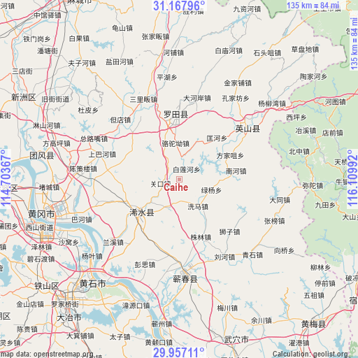
Caihe GPS coordinates[2]
30° 33' 51.912" North, 115° 24' 24.444" East
| Map corner | latitude | longitude |
|---|---|---|
| Upper-left | 31.16796°, | 114.70367° |
| Center: | 30.56442°, | 115.40679° |
| Lower-right: | 29.95711°, | 116.10992° |
| Map W x H: | 134.6×134.6 km | = 83.6×83.6mi |
| max Lat: | 53.31946° ⇑49.2% North |
| Caihe: | 30.56442° |
| min Lat: | ⇓50.8% South 18.22056° |
| min Long | Caihe | max Long |
| 75.07348° | 115.40679° | 134.28917° |
| W 56.4%⇐ | ⇒43.6% E |
Elevation
Elevation of Caihe is 59 m = 194 ft, and this is 425.8 m = 1397 ft below average elevation for this country.
| Max E: |
5622 m = 18445 ft | 68.2% |
| Avg. | 484.8 m = 1591 ft | |
| Caihe | 59 m = 194 ft | |
Min E: |
-3 m = -10 ft | 31.8% |
See also: China elevation on elevation.city.
Geographical zone
Caihe is located in North temperate zone (between Tropic of Cancer and the Arctic Circle). Distance of this Northern Tropic circle is 792.5 km =492.4 mi to South.| Distance of | km | miles | from Caihe |
|---|---|---|---|
| North Pole | 6608.6 | 4106.4 | to North |
| Arctic Circle | 4002.7 | 2487.2 | to North |
| Tropic Cancer | 792.5 | 492.4 | to South |
| Equator | 3398.4 | 2111.7 | to South |


Nearby cities:
15 places around Caihe: (largest is in red/bold)
• Bailian
4.8 km =3 mi,  44°
44°
• Bailianhe
4.7 km =2.9 mi, 36°
• Fangjiazui
21.2 km =13.2 mi,  64°
64°
• Fengshan
25 km =15.5 mi,  356°
356°
• Guankou
7.2 km =4.5 mi,  257°
257°
• Kuanghe
21.1 km =13.1 mi, 42°
• Luotuo’ao
13.6 km =8.5 mi,  354°
354°
• Lüyang
12.8 km =8 mi,  108°
108°
• Nanhe
21.6 km =13.4 mi,  81°
81°
• Qingquan
19.2 km =11.9 mi,  228°
228°
• Shizi
27.2 km =16.9 mi,  136°
136°
• Tuanbei
25 km =15.5 mi,  316°
316°
• Wanggang
23.3 km =14.5 mi,  286°
286°
• Xima
12.3 km =7.6 mi,  148°
148°
• Zhulin
23.2 km =14.4 mi,  159°
159°
Sources, notices
• [Note1] Compared only with cities in China existing in our database
• [Src1] Map data: © OpenStreetMap contributors (CC-BY-SA)
• [Src2] Other city data from geonames.org with taken over terms of usage.
• [Src3] Geographical zone / Annual Mean Temperature by Robert A. Rohde @ Wikipedia
