Guankou geodata
Guankou (Hubei) is a seat of a fourth-order administrative division; located in China in Asia/Shanghai (GMT+8) time zone. In our database, there are 1268 cities with bigger population. Compared to other cities in China, 50.8% of cities are located further ↓South; 56% of cities are located further ←West and 68.9% of cities have higher elevation than Guankou. Note1


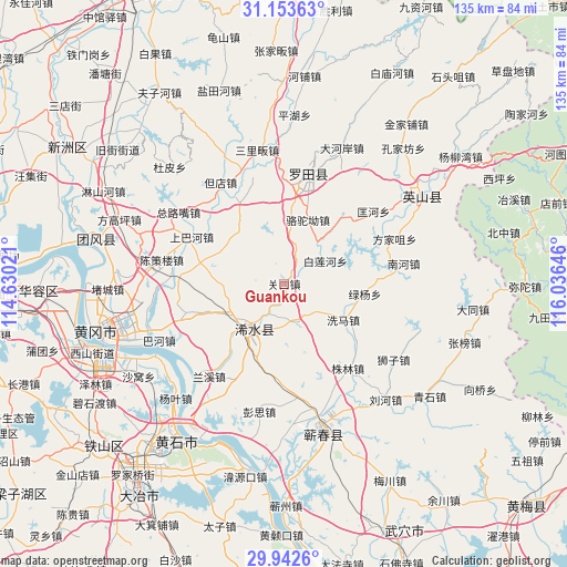
Guankou GPS coordinates[2]
30° 33' 0" North, 115° 19' 59.988" East
| Map corner | latitude | longitude |
|---|---|---|
| Upper-left | 31.15363°, | 114.63021° |
| Center: | 30.55°, | 115.33333° |
| Lower-right: | 29.9426°, | 116.03646° |
| Map W x H: | 134.7×134.7 km | = 83.7×83.7mi |
| max Lat: | 53.31946° ⇑49.2% North |
| Guankou: | 30.55° |
| min Lat: | ⇓50.8% South 18.22056° |
| min Long | Guankou | max Long |
| 75.07348° | 115.33333° | 134.28917° |
| W 56%⇐ | ⇒44% E |
Elevation
Elevation of Guankou is 56 m = 184 ft, and this is 428.8 m = 1407 ft below average elevation for this country.
| Max E: |
5622 m = 18445 ft | 68.9% |
| Avg. | 484.8 m = 1591 ft | |
| Guankou | 56 m = 184 ft | |
Min E: |
-3 m = -10 ft | 31.1% |
See also: China elevation on elevation.city.
Geographical zone
Guankou is located in North temperate zone (between Tropic of Cancer and the Arctic Circle). Distance of this Northern Tropic circle is 790.9 km =491.4 mi to South.| Distance of | km | miles | from Guankou |
|---|---|---|---|
| North Pole | 6610.2 | 4107.4 | to North |
| Arctic Circle | 4004.3 | 2488.2 | to North |
| Tropic Cancer | 790.9 | 491.4 | to South |
| Equator | 3396.8 | 2110.7 | to South |


Nearby cities:
15 places around Guankou: (largest is in red/bold)
• Bailian
11.5 km =7.1 mi,  64°
64°
• Bailianhe
11.2 km =7 mi, 61°
• Caihe
7.2 km =4.5 mi,  77°
77°
• Fengshan
27.1 km =16.8 mi,  11°
11°
• Hengche
27.1 km =16.8 mi,  173°
173°
• Kuanghe
27.3 km =17 mi,  50°
50°
• Luotuo’ao
16.2 km =10.1 mi,  20°
20°
• Lüyang
19.4 km =12.1 mi,  97°
97°
• Qingquan
13.3 km =8.3 mi,  214°
214°
• Shangbahe
24.6 km =15.3 mi,  297°
297°
• Tuanbei
22.3 km =13.9 mi,  333°
333°
• Wanggang
17.4 km =10.8 mi, 297°
• Xima
16.1 km =10 mi,  123°
123°
• Zhulin
25.2 km =15.7 mi,  142°
142°
• Zhuwa
21.3 km =13.2 mi,  283°
283°
Sources, notices
• [Note1] Compared only with cities in China existing in our database
• [Src1] Map data: © OpenStreetMap contributors (CC-BY-SA)
• [Src2] Other city data from geonames.org with taken over terms of usage.
• [Src3] Geographical zone / Annual Mean Temperature by Robert A. Rohde @ Wikipedia
