Qingjiang geodata
Qingjiang (Jiangxi) is a seat of a fourth-order administrative division; located in China in Asia/Shanghai (GMT+8) time zone. In our database, there are 1268 cities with bigger population. Compared to other cities in China, 63.3% of cities are located further ↑North; 53% of cities are located further ←West and 64.3% of cities have higher elevation than Qingjiang. Note1


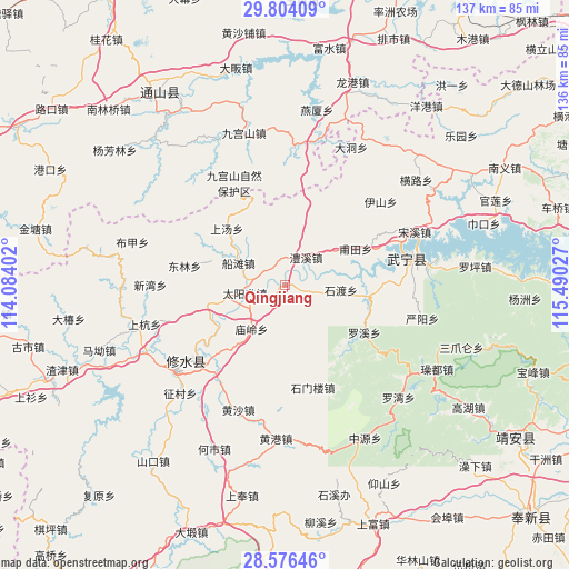
Qingjiang GPS coordinates[2]
29° 11' 31.596" North, 114° 47' 13.704" East
| Map corner | latitude | longitude |
|---|---|---|
| Upper-left | 29.80409°, | 114.08402° |
| Center: | 29.19211°, | 114.78714° |
| Lower-right: | 28.57646°, | 115.49027° |
| Map W x H: | 136.5×136.5 km | = 84.8×84.8mi |
| max Lat: | 53.31946° ⇑63.3% North |
| Qingjiang: | 29.19211° |
| min Lat: | ⇓36.7% South 18.22056° |
| min Long | Qingjiang | max Long |
| 75.07348° | 114.78714° | 134.28917° |
| W 53%⇐ | ⇒47% E |
Elevation
Elevation of Qingjiang is 76 m = 249 ft, and this is 408.8 m = 1341 ft below average elevation for this country.
| Max E: |
5622 m = 18445 ft | 64.3% |
| Avg. | 484.8 m = 1591 ft | |
| Qingjiang | 76 m = 249 ft | |
Min E: |
-3 m = -10 ft | 35.7% |
See also: China elevation on elevation.city.
Geographical zone
Qingjiang is located in North temperate zone (between Tropic of Cancer and the Arctic Circle). Distance of this Northern Tropic circle is 639.9 km =397.6 mi to South.| Distance of | km | miles | from Qingjiang |
|---|---|---|---|
| North Pole | 6761.2 | 4201.2 | to North |
| Arctic Circle | 4155.3 | 2582 | to North |
| Tropic Cancer | 639.9 | 397.6 | to South |
| Equator | 3245.9 | 2016.9 | to South |


Nearby cities:
15 places around Qingjiang: (largest is in red/bold)
• Chuantan
12.4 km =7.7 mi,  295°
295°
• Donglin
24.6 km =15.3 mi,  280°
280°
• Futian
18.7 km =11.6 mi,  63°
63°
• Huangsha
32 km =19.9 mi,  200°
200°
• Huang’ao
23.7 km =14.7 mi,  175°
175°
• Lixi
8 km =5 mi,  38°
38°
• Luoxi
22.1 km =13.7 mi,  120°
120°
• Miaoling
12.6 km =7.8 mi,  219°
219°
• Sandu
10.1 km =6.3 mi,  258°
258°
• Shangtang
19.5 km =12.1 mi,  313°
313°
• Shidu
14.3 km =8.9 mi,  81°
81°
• Shimenlou
25.5 km =15.8 mi,  165°
165°
• Sidu
19.6 km =12.2 mi, 256°
• Xinning
30.6 km =19 mi, 80°
• Yining
27.8 km =17.3 mi,  231°
231°
Sources, notices
• [Note1] Compared only with cities in China existing in our database
• [Src1] Map data: © OpenStreetMap contributors (CC-BY-SA)
• [Src2] Other city data from geonames.org with taken over terms of usage.
• [Src3] Geographical zone / Annual Mean Temperature by Robert A. Rohde @ Wikipedia
