Chuantan geodata
Chuantan (Jiangxi) is a seat of a fourth-order administrative division; located in China in Asia/Shanghai (GMT+8) time zone. In our database, there are 1268 cities with bigger population. Compared to other cities in China, 62.8% of cities are located further ↑North; 52.4% of cities are located further ←West and 57.7% of cities have higher elevation than Chuantan. Note1


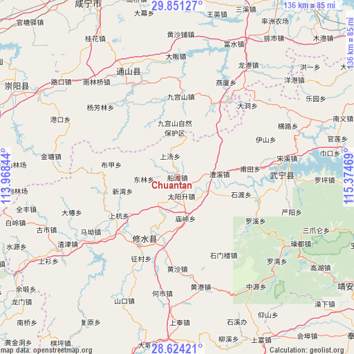
Chuantan GPS coordinates[2]
29° 14' 22.488" North, 114° 40' 17.616" East
| Map corner | latitude | longitude |
|---|---|---|
| Upper-left | 29.85127°, | 113.96844° |
| Center: | 29.23958°, | 114.67156° |
| Lower-right: | 28.62421°, | 115.37469° |
| Map W x H: | 136.4×136.4 km | = 84.8×84.8mi |
| max Lat: | 53.31946° ⇑62.8% North |
| Chuantan: | 29.23958° |
| min Lat: | ⇓37.2% South 18.22056° |
| min Long | Chuantan | max Long |
| 75.07348° | 114.67156° | 134.28917° |
| W 52.4%⇐ | ⇒47.6% E |
Elevation
Elevation of Chuantan is 113 m = 371 ft, and this is 371.8 m = 1220 ft below average elevation for this country.
| Max E: |
5622 m = 18445 ft | 57.7% |
| Avg. | 484.8 m = 1591 ft | |
| Chuantan | 113 m = 371 ft | |
Min E: |
-3 m = -10 ft | 42.3% |
See also: China elevation on elevation.city.
Geographical zone
Chuantan is located in North temperate zone (between Tropic of Cancer and the Arctic Circle). Distance of this Northern Tropic circle is 645.2 km =400.9 mi to South.| Distance of | km | miles | from Chuantan |
|---|---|---|---|
| North Pole | 6755.9 | 4197.9 | to North |
| Arctic Circle | 4150 | 2578.7 | to North |
| Tropic Cancer | 645.2 | 400.9 | to South |
| Equator | 3251.1 | 2020.1 | to South |


Nearby cities:
15 places around Chuantan: (largest is in red/bold)
• Bujia
25.9 km =16.1 mi,  281°
281°
• Chuangwang
28.9 km =18 mi,  349°
349°
• Donglin
12.9 km =8 mi,  267°
267°
• Futian
28.1 km =17.5 mi,  83°
83°
• Lixi
16.2 km =10.1 mi,  86°
86°
• Miaoling
15.4 km =9.6 mi,  168°
168°
• Qingjiang
12.4 km =7.7 mi,  115°
115°
• Sandu
7.3 km =4.5 mi, 169°
• Shanghang
27.1 km =16.8 mi,  236°
236°
• Shangtang
8.7 km =5.4 mi,  340°
340°
• Shidu
25.5 km =15.8 mi,  97°
97°
• Sidu
12.6 km =7.8 mi,  218°
218°
• Xikou
29.9 km =18.6 mi,  253°
253°
• Xinwan
21.8 km =13.5 mi,  256°
256°
• Yining
24.9 km =15.5 mi,  204°
204°
Sources, notices
• [Note1] Compared only with cities in China existing in our database
• [Src1] Map data: © OpenStreetMap contributors (CC-BY-SA)
• [Src2] Other city data from geonames.org with taken over terms of usage.
• [Src3] Geographical zone / Annual Mean Temperature by Robert A. Rohde @ Wikipedia
