Yunti geodata
Yunti (Anhui) is a seat of a fourth-order administrative division; located in China in Asia/Shanghai (GMT+8) time zone. In our database, there are 1268 cities with bigger population. Compared to other cities in China, 50.6% of cities are located further ↑North; 77.4% of cities are located further ←West and 51.9% of cities have lower elevation than Yunti. Note1


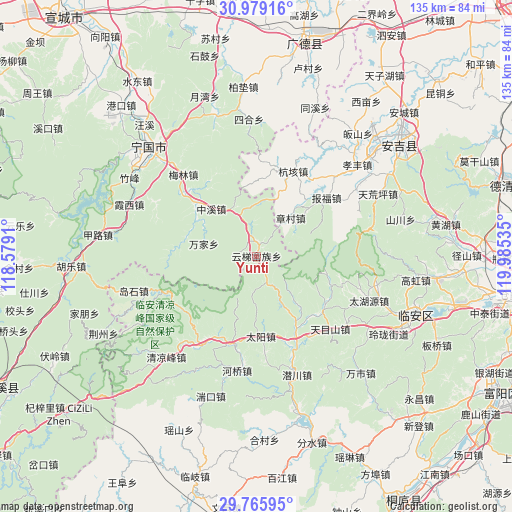
Yunti GPS coordinates[2]
30° 22' 27.984" North, 119° 16' 55.992" East
| Map corner | latitude | longitude |
|---|---|---|
| Upper-left | 30.97916°, | 118.5791° |
| Center: | 30.37444°, | 119.28222° |
| Lower-right: | 29.76595°, | 119.98535° |
| Map W x H: | 134.9×134.9 km | = 83.8×83.8mi |
| max Lat: | 53.31946° ⇑50.6% North |
| Yunti: | 30.37444° |
| min Lat: | ⇓49.4% South 18.22056° |
| min Long | Yunti | max Long |
| 75.07348° | 119.28222° | 134.28917° |
| W 77.4%⇐ | ⇒22.6% E |
Elevation
Elevation of Yunti is 180 m = 591 ft, and this is 304.8 m = 1000 ft below average elevation for this country.
| Max E: |
5622 m = 18445 ft | 48.1% |
| Avg. | 484.8 m = 1591 ft | |
| Yunti | 180 m = 591 ft | |
Min E: |
-3 m = -10 ft | 51.9% |
See also: China elevation on elevation.city.
Geographical zone
Yunti is located in North temperate zone (between Tropic of Cancer and the Arctic Circle). Distance of this Northern Tropic circle is 771.4 km =479.3 mi to South.| Distance of | km | miles | from Yunti |
|---|---|---|---|
| North Pole | 6629.7 | 4119.5 | to North |
| Arctic Circle | 4023.9 | 2500.3 | to North |
| Tropic Cancer | 771.4 | 479.3 | to South |
| Equator | 3377.3 | 2098.6 | to South |


Nearby cities:
15 places around Yunti: (largest is in red/bold)
• Changhua
23.7 km =14.7 mi,  195°
195°
• Henglu
7.8 km =4.8 mi,  156°
156°
• Longgang
28.1 km =17.5 mi,  212°
212°
• Ningdun
19.1 km =11.9 mi,  299°
299°
• Qianhong
16.7 km =10.4 mi,  139°
139°
• Taiyang
21.1 km =13.1 mi,  176°
176°
• Wanjia
14.7 km =9.1 mi,  283°
283°
• Xitianmu
21.9 km =13.6 mi,  123°
123°
• Yejia
3.7 km =2.3 mi,  8°
8°
• Yuqian
23.3 km =14.5 mi,  152°
152°
• Yutiao
26.7 km =16.6 mi,  249°
249°
• Zaoxi
27.8 km =17.3 mi,  134°
134°
• Zhangcun
13.4 km =8.3 mi,  41°
41°
• Zhongxi
17.2 km =10.7 mi,  316°
316°
• Zhujiaqiao
20.8 km =12.9 mi, 277°
Sources, notices
• [Note1] Compared only with cities in China existing in our database
• [Src1] Map data: © OpenStreetMap contributors (CC-BY-SA)
• [Src2] Other city data from geonames.org with taken over terms of usage.
• [Src3] Geographical zone / Annual Mean Temperature by Robert A. Rohde @ Wikipedia
