Puzi geodata
Puzi (Hunan) is a populated place; located in China in Asia/Shanghai (GMT+8) time zone. With population of 1,450 people, there are 1098 cities with bigger population in this country. Compared to other cities in China, 78.6% of cities are located further ↑North; 72.4% of cities are located further →East and 64.9% of cities have lower elevation than Puzi. Note1


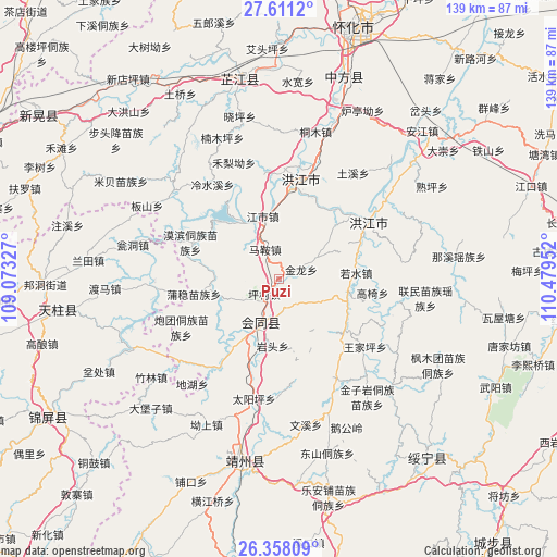
Puzi GPS coordinates[2]
26° 59' 11.004" North, 109° 46' 35.004" East
| Map corner | latitude | longitude |
|---|---|---|
| Upper-left | 27.6112°, | 109.07327° |
| Center: | 26.98639°, | 109.77639° |
| Lower-right: | 26.35809°, | 110.47952° |
| Map W x H: | 139.3×139.3 km | = 86.6×86.6mi |
| max Lat: | 53.31946° ⇑78.6% North |
| Puzi: | 26.98639° |
| min Lat: | ⇓21.4% South 18.22056° |
| min Long | Puzi | max Long |
| 75.07348° | 109.77639° | 134.28917° |
| W 27.6%⇐ | ⇒72.4% E |
Elevation
Elevation of Puzi is 323 m = 1060 ft, and this is 161.8 m = 531 ft below average elevation for this country.
| Max E: |
5622 m = 18445 ft | 35.1% |
| Avg. | 484.8 m = 1591 ft | |
| Puzi | 323 m = 1060 ft | |
Min E: |
-3 m = -10 ft | 64.9% |
See also: China elevation on elevation.city.
Geographical zone
Puzi is located in North temperate zone (between Tropic of Cancer and the Arctic Circle). Distance of this Northern Tropic circle is 394.7 km =245.3 mi to South.| Distance of | km | miles | from Puzi |
|---|---|---|---|
| North Pole | 7006.5 | 4353.6 | to North |
| Arctic Circle | 4400.6 | 2734.4 | to North |
| Tropic Cancer | 394.7 | 245.3 | to South |
| Equator | 3000.6 | 1864.5 | to South |


Nearby cities:
15 places around Puzi: (largest is in red/bold)
• Baishi
33 km =20.5 mi,  267°
267°
• Gaoyi
23.9 km =14.9 mi,  97°
97°
• Guangping
26.8 km =16.7 mi,  214°
214°
• Hongjiang
25.7 km =16 mi,  57°
57°
• Jiangdong
31.7 km =19.7 mi, 270°
• Jiangshi
15.7 km =9.8 mi,  345°
345°
• Lianshan
21.6 km =13.4 mi,  199°
199°
• Lincheng
17.2 km =10.7 mi,  220°
220°
• Mobin Tongzumiaozuxiang
23.7 km =14.7 mi,  292°
292°
• Qiancheng
22.1 km =13.7 mi,  357°
357°
• Ruoshui
18.9 km =11.7 mi,  84°
84°
• Shawan
34.5 km =21.4 mi,  46°
46°
• Shuangxi
28 km =17.4 mi,  16°
16°
• Tuokou
21.5 km =13.4 mi,  315°
315°
• Xinglong
34 km =21.1 mi,  254°
254°
Sources, notices
• [Note1] Compared only with cities in China existing in our database
• [Src1] Map data: © OpenStreetMap contributors (CC-BY-SA)
• [Src2] Other city data from geonames.org with taken over terms of usage.
• [Src3] Geographical zone / Annual Mean Temperature by Robert A. Rohde @ Wikipedia
