Lianshan geodata
Lianshan (Hunan) is a populated place; located in China in Asia/Shanghai (GMT+8) time zone. With population of 1,000 people, there are 1171 cities with bigger population in this country. Compared to other cities in China, 79.3% of cities are located further ↑North; 72.8% of cities are located further →East and 62.4% of cities have lower elevation than Lianshan. Note1


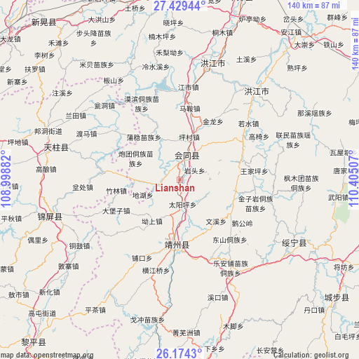
Lianshan GPS coordinates[2]
26° 48' 12.996" North, 109° 42' 6.984" East
| Map corner | latitude | longitude |
|---|---|---|
| Upper-left | 27.42944°, | 108.99882° |
| Center: | 26.80361°, | 109.70194° |
| Lower-right: | 26.1743°, | 110.40507° |
| Map W x H: | 139.6×139.6 km | = 86.7×86.7mi |
| max Lat: | 53.31946° ⇑79.3% North |
| Lianshan: | 26.80361° |
| min Lat: | ⇓20.7% South 18.22056° |
| min Long | Lianshan | max Long |
| 75.07348° | 109.70194° | 134.28917° |
| W 27.2%⇐ | ⇒72.8% E |
Elevation
Elevation of Lianshan is 288 m = 945 ft, and this is 196.8 m = 646 ft below average elevation for this country.
| Max E: |
5622 m = 18445 ft | 37.6% |
| Avg. | 484.8 m = 1591 ft | |
| Lianshan | 288 m = 945 ft | |
Min E: |
-3 m = -10 ft | 62.4% |
See also: China elevation on elevation.city.
Geographical zone
Lianshan is located in North temperate zone (between Tropic of Cancer and the Arctic Circle). Distance of this Northern Tropic circle is 374.4 km =232.6 mi to South.| Distance of | km | miles | from Lianshan |
|---|---|---|---|
| North Pole | 7026.8 | 4366.2 | to North |
| Arctic Circle | 4420.9 | 2747 | to North |
| Tropic Cancer | 374.4 | 232.6 | to South |
| Equator | 2980.3 | 1851.9 | to South |


Nearby cities:
15 places around Lianshan: (largest is in red/bold)
• Baishi
31.9 km =19.8 mi,  306°
306°
• Dabaozi
27.9 km =17.3 mi,  244°
244°
• Dongshan Dongzuxiang
30.2 km =18.8 mi,  140°
140°
• Gaoyi
35.6 km =22.1 mi,  60°
60°
• Guangping
8 km =5 mi,  256°
256°
• Jiangdong
31.8 km =19.8 mi, 309°
• Jiangshi
35.7 km =22.2 mi,  5°
5°
• Lincheng
8.2 km =5.1 mi,  332°
332°
• Mobin Tongzumiaozuxiang
32.7 km =20.3 mi, 333°
• Pukou
34.5 km =21.4 mi,  204°
204°
• Puzi
21.6 km =13.4 mi,  19°
19°
• Quyang
26.2 km =16.3 mi,  194°
194°
• Ruoshui
34.3 km =21.3 mi,  49°
49°
• Tuokou
36.5 km =22.7 mi,  347°
347°
• Xinglong
28 km =17.4 mi,  294°
294°
Sources, notices
• [Note1] Compared only with cities in China existing in our database
• [Src1] Map data: © OpenStreetMap contributors (CC-BY-SA)
• [Src2] Other city data from geonames.org with taken over terms of usage.
• [Src3] Geographical zone / Annual Mean Temperature by Robert A. Rohde @ Wikipedia
