Gaoyi geodata
Gaoyi (Hunan) is a populated place; located in China in Asia/Shanghai (GMT+8) time zone. With population of 1,110 people, there are 1152 cities with bigger population in this country. Compared to other cities in China, 78.8% of cities are located further ↑North; 71.2% of cities are located further →East and 62.5% of cities have lower elevation than Gaoyi. Note1


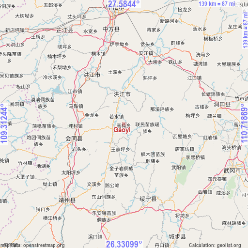
Gaoyi GPS coordinates[2]
26° 57' 33.984" North, 110° 0' 56.016" East
| Map corner | latitude | longitude |
|---|---|---|
| Upper-left | 27.5844°, | 109.31244° |
| Center: | 26.95944°, | 110.01556° |
| Lower-right: | 26.33099°, | 110.71869° |
| Map W x H: | 139.4×139.4 km | = 86.6×86.6mi |
| max Lat: | 53.31946° ⇑78.8% North |
| Gaoyi: | 26.95944° |
| min Lat: | ⇓21.2% South 18.22056° |
| min Long | Gaoyi | max Long |
| 75.07348° | 110.01556° | 134.28917° |
| W 28.8%⇐ | ⇒71.2% E |
Elevation
Elevation of Gaoyi is 290 m = 951 ft, and this is 194.8 m = 639 ft below average elevation for this country.
| Max E: |
5622 m = 18445 ft | 37.5% |
| Avg. | 484.8 m = 1591 ft | |
| Gaoyi | 290 m = 951 ft | |
Min E: |
-3 m = -10 ft | 62.5% |
See also: China elevation on elevation.city.
Geographical zone
Gaoyi is located in North temperate zone (between Tropic of Cancer and the Arctic Circle). Distance of this Northern Tropic circle is 391.7 km =243.4 mi to South.| Distance of | km | miles | from Gaoyi |
|---|---|---|---|
| North Pole | 7009.5 | 4355.5 | to North |
| Arctic Circle | 4403.6 | 2736.3 | to North |
| Tropic Cancer | 391.7 | 243.4 | to South |
| Equator | 2997.6 | 1862.6 | to South |


Nearby cities:
15 places around Gaoyi: (largest is in red/bold)
• Hekou
24.6 km =15.3 mi,  168°
168°
• Hongjiang
16.9 km =10.5 mi,  353°
353°
• Huangtukuang
39.2 km =24.4 mi,  97°
97°
• Jiangshi
33 km =20.5 mi,  303°
303°
• Lianshan
35.6 km =22.1 mi,  240°
240°
• Lincheng
36.3 km =22.6 mi,  253°
253°
• Puzi
23.9 km =14.9 mi,  277°
277°
• Qiancheng
35.2 km =21.9 mi,  315°
315°
• Ruoshui
6.8 km =4.2 mi,  314°
314°
• Shawan
26.9 km =16.7 mi,  2°
2°
• Shuangxi
33.8 km =21 mi,  332°
332°
• Shuping
28.1 km =17.5 mi,  24°
24°
• Tangjiafang
37.1 km =23.1 mi,  110°
110°
• Wuyang
39.3 km =24.4 mi,  127°
127°
• Zhuzhoujiang Miaozuxiang
32.1 km =19.9 mi, 169°
Sources, notices
• [Note1] Compared only with cities in China existing in our database
• [Src1] Map data: © OpenStreetMap contributors (CC-BY-SA)
• [Src2] Other city data from geonames.org with taken over terms of usage.
• [Src3] Geographical zone / Annual Mean Temperature by Robert A. Rohde @ Wikipedia
