Pingshan geodata
Pingshan (Guangdong) is a seat of a third-order administrative division; located in China in Asia/Shanghai (GMT+8) time zone. With population of 113,631 people, there are 382 cities with bigger population in this country. Compared to other cities in China, 94.5% of cities are located further ↑North; 52.7% of cities are located further ←West and 82.1% of cities have higher elevation than Pingshan. Note1


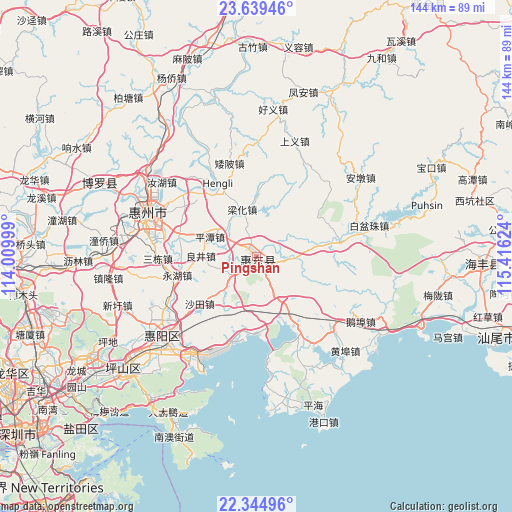
Pingshan GPS coordinates[2]
22° 59' 37.536" North, 114° 42' 47.196" East
| Map corner | latitude | longitude |
|---|---|---|
| Upper-left | 23.63946°, | 114.00999° |
| Center: | 22.99376°, | 114.71311° |
| Lower-right: | 22.34496°, | 115.41624° |
| Map W x H: | 143.9×143.9 km | = 89.4×89.4mi |
| max Lat: | 53.31946° ⇑94.5% North |
| Pingshan: | 22.99376° |
| min Lat: | ⇓5.5% South 18.22056° |
| min Long | Pingshan | max Long |
| 75.07348° | 114.71311° | 134.28917° |
| W 52.7%⇐ | ⇒47.3% E |
Elevation
Elevation of Pingshan is 22 m = 72 ft, and this is 462.8 m = 1518 ft below average elevation for this country.
| Max E: |
5622 m = 18445 ft | 82.1% |
| Avg. | 484.8 m = 1591 ft | |
| Pingshan | 22 m = 72 ft | |
Min E: |
-3 m = -10 ft | 17.9% |
See also: Pingshan elevation on elevation.city.
Geographical zone
Pingshan is located in North Torrid zone (between Equator and Tropic of Cancer). Distance of this Northern Tropic circle is 49.3 km =30.6 mi to North.| Distance of | km | miles | from Pingshan |
|---|---|---|---|
| North Pole | 7450.4 | 4629.5 | to North |
| Arctic Circle | 4844.5 | 3010.2 | to North |
| Tropic Cancer | 49.3 | 30.6 | to North |
| Equator | 2556.7 | 1588.7 | to South |


Nearby cities:
15 places around Pingshan: (largest is in red/bold)
• Baihua
7.9 km =4.9 mi,  236°
236°
• Daling
3 km =1.9 mi,  323°
323°
• Duozhu
24.2 km =15 mi,  80°
80°
• Hengli
21.9 km =13.6 mi,  334°
334°
• Lianghua
14.2 km =8.8 mi,  345°
345°
• Liangjing
15 km =9.3 mi,  274°
274°
• Ma’an
22.3 km =13.9 mi,  285°
285°
• Pingtan
14.7 km =9.1 mi,  295°
295°
• Renshan
19.9 km =12.4 mi,  151°
151°
• Sandong
27.2 km =16.9 mi, 270°
• Shatian
21 km =13 mi,  231°
231°
• Shuikou
26.5 km =16.5 mi,  312°
312°
• Xiayong
23.8 km =14.8 mi,  196°
196°
• Yonghu
23.6 km =14.7 mi,  258°
258°
• Zengguang
16.5 km =10.3 mi, 80°
Sources, notices
• [Note1] Compared only with cities in China existing in our database
• [Src1] Map data: © OpenStreetMap contributors (CC-BY-SA)
• [Src2] Other city data from geonames.org with taken over terms of usage.
• [Src3] Geographical zone / Annual Mean Temperature by Robert A. Rohde @ Wikipedia
