Fangxian geodata
Fangxian (Jiangsu) is a seat of a fourth-order administrative division; located in China in Asia/Shanghai (GMT+8) time zone. In our database, there are 1268 cities with bigger population. Compared to other cities in China, 61.2% of cities are located further ↓South; 80.2% of cities are located further ←West and 92.7% of cities have higher elevation than Fangxian. Note1


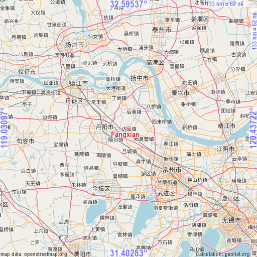
Fangxian GPS coordinates[2]
32° 0' 3.744" North, 119° 44' 2.724" East
| Map corner | latitude | longitude |
|---|---|---|
| Upper-left | 32.59537°, | 119.03097° |
| Center: | 32.00104°, | 119.73409° |
| Lower-right: | 31.40283°, | 120.43722° |
| Map W x H: | 132.6×132.6 km | = 82.4×82.4mi |
| max Lat: | 53.31946° ⇑38.8% North |
| Fangxian: | 32.00104° |
| min Lat: | ⇓61.2% South 18.22056° |
| min Long | Fangxian | max Long |
| 75.07348° | 119.73409° | 134.28917° |
| W 80.2%⇐ | ⇒19.8% E |
Elevation
Elevation of Fangxian is 8 m = 26 ft, and this is 476.8 m = 1564 ft below average elevation for this country.
| Max E: |
5622 m = 18445 ft | 92.7% |
| Avg. | 484.8 m = 1591 ft | |
| Fangxian | 8 m = 26 ft | |
Min E: |
-3 m = -10 ft | 7.3% |
See also: China elevation on elevation.city.
Geographical zone
Fangxian is located in North temperate zone (between Tropic of Cancer and the Arctic Circle). Distance of this Northern Tropic circle is 952.3 km =591.7 mi to South.| Distance of | km | miles | from Fangxian |
|---|---|---|---|
| North Pole | 6448.9 | 4007.2 | to North |
| Arctic Circle | 3843 | 2387.9 | to North |
| Tropic Cancer | 952.3 | 591.7 | to South |
| Equator | 3558.2 | 2211 | to South |


Nearby cities:
15 places around Fangxian: (largest is in red/bold)
• Baqiao
17.9 km =11.1 mi,  47°
47°
• Benniu
17.1 km =10.6 mi,  155°
155°
• Dinggang
16.5 km =10.3 mi,  343°
343°
• Houxiang
11.7 km =7.3 mi,  12°
12°
• Jiepai
13.8 km =8.6 mi, 54°
• Lingkou
9.5 km =5.9 mi,  233°
233°
• Luoxi
12.6 km =7.8 mi,  148°
148°
• Lücheng
11.4 km =7.1 mi,  179°
179°
• Menghe
11 km =6.8 mi,  81°
81°
• Picheng
13.4 km =8.3 mi,  347°
347°
• Xilaiqiao
17.3 km =10.7 mi, 76°
• Xinqiao
10.6 km =6.6 mi,  39°
39°
• Xixiashu
9.9 km =6.2 mi,  124°
124°
• Youfang
17.6 km =10.9 mi, 36°
• Yunyang
16 km =9.9 mi,  267°
267°
Sources, notices
• [Note1] Compared only with cities in China existing in our database
• [Src1] Map data: © OpenStreetMap contributors (CC-BY-SA)
• [Src2] Other city data from geonames.org with taken over terms of usage.
• [Src3] Geographical zone / Annual Mean Temperature by Robert A. Rohde @ Wikipedia
