Lidao geodata
Lidao (Shandong) is a seat of a fourth-order administrative division; located in China in Asia/Shanghai (GMT+8) time zone. In our database, there are 1268 cities with bigger population. Compared to other cities in China, 79.7% of cities are located further ↓South; 92.2% of cities are located further ←West and 94.3% of cities have higher elevation than Lidao. Note1


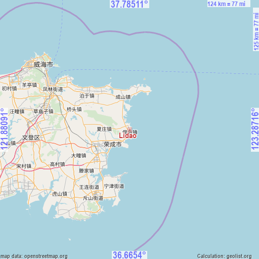
Lidao GPS coordinates[2]
37° 13' 38.388" North, 122° 35' 2.508" East
| Map corner | latitude | longitude |
|---|---|---|
| Upper-left | 37.78511°, | 121.88091° |
| Center: | 37.22733°, | 122.58403° |
| Lower-right: | 36.6654°, | 123.28716° |
| Map W x H: | 124.5×124.5 km | = 77.4×77.4mi |
| max Lat: | 53.31946° ⇑20.3% North |
| Lidao: | 37.22733° |
| min Lat: | ⇓79.7% South 18.22056° |
| min Long | Lidao | max Long |
| 75.07348° | 122.58403° | 134.28917° |
| W 92.2%⇐ | ⇒7.8% E |
Elevation
Elevation of Lidao is 7 m = 23 ft, and this is 477.8 m = 1568 ft below average elevation for this country.
| Max E: |
5622 m = 18445 ft | 94.3% |
| Avg. | 484.8 m = 1591 ft | |
| Lidao | 7 m = 23 ft | |
Min E: |
-3 m = -10 ft | 5.7% |
See also: China elevation on elevation.city.
Geographical zone
Lidao is located in North temperate zone (between Tropic of Cancer and the Arctic Circle). Distance of this Northern Tropic circle is 1533.4 km =952.8 mi to South.| Distance of | km | miles | from Lidao |
|---|---|---|---|
| North Pole | 5867.8 | 3646.1 | to North |
| Arctic Circle | 3261.9 | 2026.9 | to North |
| Tropic Cancer | 1533.4 | 952.8 | to South |
| Equator | 4139.3 | 2572 | to South |


Nearby cities:
15 places around Lidao: (largest is in red/bold)
• Boyu
26.7 km =16.6 mi,  308°
308°
• Buliu
18.2 km =11.3 mi, 311°
• Chengshan
15.8 km =9.8 mi,  349°
349°
• Dashuipo
30.2 km =18.8 mi,  261°
261°
• Datuan
27.3 km =17 mi,  243°
243°
• Dongshan
32 km =19.9 mi,  203°
203°
• Gangxi
21.9 km =13.6 mi,  321°
321°
• Ningjin
27.8 km =17.3 mi, 195°
• Qiaotou
28.7 km =17.8 mi,  290°
290°
• Tengjia
27.9 km =17.3 mi,  228°
228°
• Wanglian
33.2 km =20.6 mi,  216°
216°
• Xiazhuang
11.6 km =7.2 mi,  272°
272°
• Yatou
15.2 km =9.4 mi, 238°
• Yaxi
19.5 km =12.1 mi,  278°
278°
• Yinzi
24.1 km =15 mi, 266°
Sources, notices
• [Note1] Compared only with cities in China existing in our database
• [Src1] Map data: © OpenStreetMap contributors (CC-BY-SA)
• [Src2] Other city data from geonames.org with taken over terms of usage.
• [Src3] Geographical zone / Annual Mean Temperature by Robert A. Rohde @ Wikipedia
