Gangwan geodata
Gangwan (Shandong) is a seat of a fourth-order administrative division; located in China in Asia/Shanghai (GMT+8) time zone. In our database, there are 1268 cities with bigger population. Compared to other cities in China, 78.9% of cities are located further ↓South; 92% of cities are located further ←West and 89.9% of cities have higher elevation than Gangwan. Note1


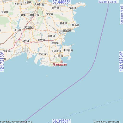
Gangwan GPS coordinates[2]
36° 52' 49.08" North, 122° 25' 28.236" East
| Map corner | latitude | longitude |
|---|---|---|
| Upper-left | 37.44065°, | 121.72139° |
| Center: | 36.8803°, | 122.42451° |
| Lower-right: | 36.31581°, | 123.12764° |
| Map W x H: | 125.1×125.1 km | = 77.7×77.7mi |
| max Lat: | 53.31946° ⇑21.1% North |
| Gangwan: | 36.8803° |
| min Lat: | ⇓78.9% South 18.22056° |
| min Long | Gangwan | max Long |
| 75.07348° | 122.42451° | 134.28917° |
| W 92%⇐ | ⇒8% E |
Elevation
Elevation of Gangwan is 10 m = 33 ft, and this is 474.8 m = 1558 ft below average elevation for this country.
| Max E: |
5622 m = 18445 ft | 89.9% |
| Avg. | 484.8 m = 1591 ft | |
| Gangwan | 10 m = 33 ft | |
Min E: |
-3 m = -10 ft | 10.1% |
See also: China elevation on elevation.city.
Geographical zone
Gangwan is located in North temperate zone (between Tropic of Cancer and the Arctic Circle). Distance of this Northern Tropic circle is 1494.8 km =928.8 mi to South.| Distance of | km | miles | from Gangwan |
|---|---|---|---|
| North Pole | 5906.4 | 3670.1 | to North |
| Arctic Circle | 3300.5 | 2050.8 | to North |
| Tropic Cancer | 1494.8 | 928.8 | to South |
| Equator | 4100.7 | 2548.1 | to South |


Nearby cities:
15 places around Gangwan: (largest is in red/bold)
• Chishan
6.7 km =4.2 mi,  331°
331°
• Dashuipo
37.4 km =23.2 mi,  335°
335°
• Datuan
28.3 km =17.6 mi, 338°
• Dongshan
9.3 km =5.8 mi,  8°
8°
• Gaocun
30.6 km =19 mi,  317°
317°
• Houjia
33.5 km =20.8 mi,  297°
297°
• Hushan
18.7 km =11.6 mi, 295°
• Ningjin
13.7 km =8.5 mi,  30°
30°
• Renhe
11.1 km =6.9 mi,  276°
276°
• Shangzhuang
18 km =11.2 mi, 317°
• Taoyuan
6.1 km =3.8 mi,  16°
16°
• Tengjia
21.1 km =13.1 mi, 341°
• Wanglian
12.9 km =8 mi, 335°
• Yatou
30.7 km =19.1 mi,  2°
2°
• Zeku
33.6 km =20.9 mi, 281°
Sources, notices
• [Note1] Compared only with cities in China existing in our database
• [Src1] Map data: © OpenStreetMap contributors (CC-BY-SA)
• [Src2] Other city data from geonames.org with taken over terms of usage.
• [Src3] Geographical zone / Annual Mean Temperature by Robert A. Rohde @ Wikipedia
