Fengtai geodata
Fengtai (Tianjin) is a populated place; located in China in Asia/Shanghai (GMT+8) time zone. With population of 7,230 people, there are 836 cities with bigger population in this country. Compared to other cities in China, 84.8% of cities are located further ↓South; 69.7% of cities are located further ←West and 97.2% of cities have higher elevation than Fengtai. Note1


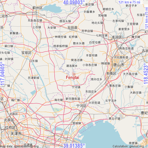
Fengtai GPS coordinates[2]
39° 33' 29.016" North, 117° 44' 57.012" East
| Map corner | latitude | longitude |
|---|---|---|
| Upper-left | 40.09803°, | 117.04605° |
| Center: | 39.55806°, | 117.74917° |
| Lower-right: | 39.01385°, | 118.4523° |
| Map W x H: | 120.5×120.5 km | = 74.9×74.9mi |
| max Lat: | 53.31946° ⇑15.2% North |
| Fengtai: | 39.55806° |
| min Lat: | ⇓84.8% South 18.22056° |
| min Long | Fengtai | max Long |
| 75.07348° | 117.74917° | 134.28917° |
| W 69.7%⇐ | ⇒30.3% E |
Elevation
Elevation of Fengtai is 5 m = 16 ft, and this is 479.8 m = 1574 ft below average elevation for this country.
| Max E: |
5622 m = 18445 ft | 97.2% |
| Avg. | 484.8 m = 1591 ft | |
| Fengtai | 5 m = 16 ft | |
Min E: |
-3 m = -10 ft | 2.8% |
See also: China elevation on elevation.city.
Geographical zone
Fengtai is located in North temperate zone (between Tropic of Cancer and the Arctic Circle). Distance of this Northern Tropic circle is 1792.5 km =1113.8 mi to South.| Distance of | km | miles | from Fengtai |
|---|---|---|---|
| North Pole | 5608.6 | 3485 | to North |
| Arctic Circle | 3002.7 | 1865.8 | to North |
| Tropic Cancer | 1792.5 | 1113.8 | to South |
| Equator | 4398.4 | 2733 | to South |


Nearby cities:
15 places around Fengtai: (largest is in red/bold)
• Bamencheng
12.5 km =7.8 mi,  280°
280°
• Dadengzhuang
13.8 km =8.6 mi,  234°
234°
• Daxinzhuang
8.1 km =5 mi,  221°
221°
• Dazhongzhuang
20.9 km =13 mi,  310°
310°
• Dongjituo
21.3 km =13.2 mi, 224°
• Gaojingzhuang
18.8 km =11.7 mi,  212°
212°
• Huangzhuang
21.9 km =13.6 mi,  247°
247°
• Jiangwakou
5.6 km =3.5 mi, 225°
• Lianzhuang
16.5 km =10.3 mi,  177°
177°
• Lintingkou
22.8 km =14.2 mi,  290°
290°
• Miaozhuang
15.8 km =9.8 mi,  162°
162°
• Nanmaizhu
6.2 km =3.9 mi, 183°
• Ninghe
10.7 km =6.6 mi,  173°
173°
• Penguanzhuang
9.9 km =6.2 mi,  146°
146°
• Zhaobenzhuang
14.5 km =9 mi, 223°
Sources, notices
• [Note1] Compared only with cities in China existing in our database
• [Src1] Map data: © OpenStreetMap contributors (CC-BY-SA)
• [Src2] Other city data from geonames.org with taken over terms of usage.
• [Src3] Geographical zone / Annual Mean Temperature by Robert A. Rohde @ Wikipedia
