Bowang geodata
Bowang (Henan) is a seat of a fourth-order administrative division; located in China in Asia/Shanghai (GMT+8) time zone. In our database, there are 1268 cities with bigger population. Compared to other cities in China, 67% of cities are located further ↓South; 58.9% of cities are located further →East and 50.4% of cities have higher elevation than Bowang. Note1


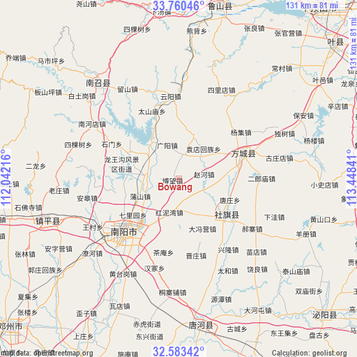
Bowang GPS coordinates[2]
33° 10' 26.112" North, 112° 44' 43.008" East
| Map corner | latitude | longitude |
|---|---|---|
| Upper-left | 33.76046°, | 112.04216° |
| Center: | 33.17392°, | 112.74528° |
| Lower-right: | 32.58342°, | 113.44841° |
| Map W x H: | 130.9×130.9 km | = 81.3×81.3mi |
| max Lat: | 53.31946° ⇑33% North |
| Bowang: | 33.17392° |
| min Lat: | ⇓67% South 18.22056° |
| min Long | Bowang | max Long |
| 75.07348° | 112.74528° | 134.28917° |
| W 41.1%⇐ | ⇒58.9% E |
Elevation
Elevation of Bowang is 161 m = 528 ft, and this is 323.8 m = 1062 ft below average elevation for this country.
| Max E: |
5622 m = 18445 ft | 50.4% |
| Avg. | 484.8 m = 1591 ft | |
| Bowang | 161 m = 528 ft | |
Min E: |
-3 m = -10 ft | 49.6% |
See also: China elevation on elevation.city.
Geographical zone
Bowang is located in North temperate zone (between Tropic of Cancer and the Arctic Circle). Distance of this Northern Tropic circle is 1082.7 km =672.8 mi to South.| Distance of | km | miles | from Bowang |
|---|---|---|---|
| North Pole | 6318.5 | 3926.1 | to North |
| Arctic Circle | 3712.6 | 2306.9 | to North |
| Tropic Cancer | 1082.7 | 672.8 | to South |
| Equator | 3688.6 | 2292 | to South |


Nearby cities:
15 places around Bowang: (largest is in red/bold)
• Chengjiao
21.8 km =13.5 mi,  129°
129°
• Dafengying
20.6 km =12.8 mi,  154°
154°
• Fangcheng Chengguanzhen
25.4 km =15.8 mi,  69°
69°
• Guangyang
12.9 km =8 mi,  341°
341°
• Huancheng
26.1 km =16.2 mi,  227°
227°
• Huangludian
13.7 km =8.5 mi,  311°
311°
• Liuhe
16.7 km =10.4 mi,  17°
17°
• Pushan
15.3 km =9.5 mi,  246°
246°
• Qiaotou
14.5 km =9 mi,  155°
155°
• Qinghe
17.2 km =10.7 mi,  60°
60°
• Shedian
22.2 km =13.8 mi,  124°
124°
• Tangzhuang
20.5 km =12.7 mi,  112°
112°
• Xuanqiao
20.3 km =12.6 mi,  96°
96°
• Yuandianhui
14.3 km =8.9 mi,  40°
40°
• Zhaohe
9.4 km =5.8 mi,  80°
80°
Sources, notices
• [Note1] Compared only with cities in China existing in our database
• [Src1] Map data: © OpenStreetMap contributors (CC-BY-SA)
• [Src2] Other city data from geonames.org with taken over terms of usage.
• [Src3] Geographical zone / Annual Mean Temperature by Robert A. Rohde @ Wikipedia
