Nanshan geodata
Nanshan (Fujian) is a seat of a fourth-order administrative division; located in China in Asia/Shanghai (GMT+8) time zone. In our database, there are 1268 cities with bigger population. Compared to other cities in China, 80% of cities are located further ↑North; 72.1% of cities are located further ←West and 58.5% of cities have higher elevation than Nanshan. Note1


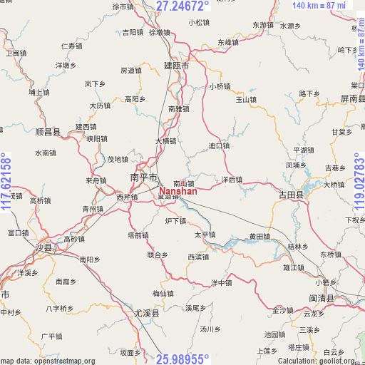
Nanshan GPS coordinates[2]
26° 37' 11.496" North, 118° 19' 28.92" East
| Map corner | latitude | longitude |
|---|---|---|
| Upper-left | 27.24672°, | 117.62158° |
| Center: | 26.61986°, | 118.3247° |
| Lower-right: | 25.98955°, | 119.02783° |
| Map W x H: | 139.8×139.8 km | = 86.9×86.9mi |
| max Lat: | 53.31946° ⇑80% North |
| Nanshan: | 26.61986° |
| min Lat: | ⇓20% South 18.22056° |
| min Long | Nanshan | max Long |
| 75.07348° | 118.3247° | 134.28917° |
| W 72.1%⇐ | ⇒27.9% E |
Elevation
Elevation of Nanshan is 108 m = 354 ft, and this is 376.8 m = 1236 ft below average elevation for this country.
| Max E: |
5622 m = 18445 ft | 58.5% |
| Avg. | 484.8 m = 1591 ft | |
| Nanshan | 108 m = 354 ft | |
Min E: |
-3 m = -10 ft | 41.5% |
See also: China elevation on elevation.city.
Geographical zone
Nanshan is located in North temperate zone (between Tropic of Cancer and the Arctic Circle). Distance of this Northern Tropic circle is 353.9 km =219.9 mi to South.| Distance of | km | miles | from Nanshan |
|---|---|---|---|
| North Pole | 7047.2 | 4378.9 | to North |
| Arctic Circle | 4441.3 | 2759.7 | to North |
| Tropic Cancer | 353.9 | 219.9 | to South |
| Equator | 2959.9 | 1839.2 | to South |


Nearby cities:
15 places around Nanshan: (largest is in red/bold)
• Chimen
14.8 km =9.2 mi,  124°
124°
• Daheng
17.6 km =10.9 mi,  337°
337°
• Dikou
20.1 km =12.5 mi,  43°
43°
• Luxia
14.7 km =9.1 mi,  191°
191°
• Mangdang
18.4 km =11.4 mi,  294°
294°
• Maodi
26.6 km =16.5 mi, 290°
• Nanping
15.3 km =9.5 mi,  280°
280°
• Nanya
28.6 km =17.8 mi,  356°
356°
• Tadou
29.2 km =18.1 mi,  198°
198°
• Taiping
21.5 km =13.4 mi,  154°
154°
• Xiadao
7.4 km =4.6 mi,  227°
227°
• Xibin
28.4 km =17.6 mi,  169°
169°
• Xiqin
22 km =13.7 mi,  256°
256°
• Yanghou
18.4 km =11.4 mi,  82°
82°
• Youxikou
27.4 km =17 mi, 154°
Sources, notices
• [Note1] Compared only with cities in China existing in our database
• [Src1] Map data: © OpenStreetMap contributors (CC-BY-SA)
• [Src2] Other city data from geonames.org with taken over terms of usage.
• [Src3] Geographical zone / Annual Mean Temperature by Robert A. Rohde @ Wikipedia
