Luxia geodata
Luxia (Fujian) is a seat of a fourth-order administrative division; located in China in Asia/Shanghai (GMT+8) time zone. In our database, there are 1268 cities with bigger population. Compared to other cities in China, 80.5% of cities are located further ↑North; 71.9% of cities are located further ←West and 60.8% of cities have higher elevation than Luxia. Note1


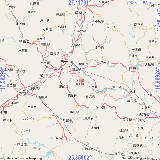
Luxia GPS coordinates[2]
26° 29' 24.144" North, 118° 17' 45.996" East
| Map corner | latitude | longitude |
|---|---|---|
| Upper-left | 27.11761°, | 117.59299° |
| Center: | 26.49004°, | 118.29611° |
| Lower-right: | 25.85902°, | 118.99924° |
| Map W x H: | 139.9×139.9 km | = 86.9×86.9mi |
| max Lat: | 53.31946° ⇑80.5% North |
| Luxia: | 26.49004° |
| min Lat: | ⇓19.5% South 18.22056° |
| min Long | Luxia | max Long |
| 75.07348° | 118.29611° | 134.28917° |
| W 71.9%⇐ | ⇒28.1% E |
Elevation
Elevation of Luxia is 94 m = 308 ft, and this is 390.8 m = 1282 ft below average elevation for this country.
| Max E: |
5622 m = 18445 ft | 60.8% |
| Avg. | 484.8 m = 1591 ft | |
| Luxia | 94 m = 308 ft | |
Min E: |
-3 m = -10 ft | 39.2% |
See also: China elevation on elevation.city.
Geographical zone
Luxia is located in North temperate zone (between Tropic of Cancer and the Arctic Circle). Distance of this Northern Tropic circle is 339.5 km =211 mi to South.| Distance of | km | miles | from Luxia |
|---|---|---|---|
| North Pole | 7061.6 | 4387.9 | to North |
| Arctic Circle | 4455.8 | 2768.7 | to North |
| Tropic Cancer | 339.5 | 211 | to South |
| Equator | 2945.4 | 1830.2 | to South |


Nearby cities:
15 places around Luxia: (largest is in red/bold)
• Chimen
16.3 km =10.1 mi,  67°
67°
• Daheng
31 km =19.3 mi,  352°
352°
• Mangdang
26 km =16.2 mi,  327°
327°
• Meixian
28.1 km =17.5 mi,  189°
189°
• Nanping
21.1 km =13.1 mi,  324°
324°
• Nanshan
14.7 km =9.1 mi,  11°
11°
• Tadou
14.7 km =9.1 mi,  206°
206°
• Taiping
13.2 km =8.2 mi,  112°
112°
• Xiadao
9.8 km =6.1 mi,  344°
344°
• Xibin
15.6 km =9.7 mi,  149°
149°
• Xiqin
20.6 km =12.8 mi,  296°
296°
• Yanghou
26.9 km =16.7 mi,  51°
51°
• Youxikou
17.9 km =11.1 mi,  124°
124°
• Zhanghuban
22 km =13.7 mi, 121°
• Zhenghu
30.8 km =19.1 mi,  242°
242°
Sources, notices
• [Note1] Compared only with cities in China existing in our database
• [Src1] Map data: © OpenStreetMap contributors (CC-BY-SA)
• [Src2] Other city data from geonames.org with taken over terms of usage.
• [Src3] Geographical zone / Annual Mean Temperature by Robert A. Rohde @ Wikipedia
