Nangu geodata
Nangu (Gansu) is a seat of a fourth-order administrative division; located in China in Asia/Shanghai (GMT+8) time zone. In our database, there are 1268 cities with bigger population. Compared to other cities in China, 81.9% of cities are located further ↓South; 94.2% of cities are located further →East and 95.3% of cities have lower elevation than Nangu. Note1


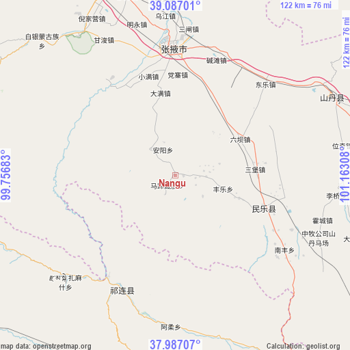
Nangu GPS coordinates[2]
38° 32' 20.904" North, 100° 27' 35.82" East
| Map corner | latitude | longitude |
|---|---|---|
| Upper-left | 39.08701°, | 99.75683° |
| Center: | 38.53914°, | 100.45995° |
| Lower-right: | 37.98707°, | 101.16308° |
| Map W x H: | 122.3×122.3 km | = 76×76mi |
| max Lat: | 53.31946° ⇑18.1% North |
| Nangu: | 38.53914° |
| min Lat: | ⇓81.9% South 18.22056° |
| min Long | Nangu | max Long |
| 75.07348° | 100.45995° | 134.28917° |
| W 5.8%⇐ | ⇒94.2% E |
Elevation
Elevation of Nangu is 2228 m = 7310 ft, and this is 1743.2 m = 5719 ft above average elevation for this country.
| Max E: |
5622 m = 18445 ft | 4.7% |
| Nangu | 2228 m 7310 ft | |
| Avg. | 484.8 m = 1591 ft | |
Min E: |
-3 m = -10 ft | 95.3% |
See also: China elevation on elevation.city.
Geographical zone
Nangu is located in North temperate zone (between Tropic of Cancer and the Arctic Circle). Distance of this Northern Tropic circle is 1679.2 km =1043.4 mi to South.| Distance of | km | miles | from Nangu |
|---|---|---|---|
| North Pole | 5721.9 | 3555.4 | to North |
| Arctic Circle | 3116 | 1936.2 | to North |
| Tropic Cancer | 1679.2 | 1043.4 | to South |
| Equator | 4285.2 | 2662.7 | to South |


Nearby cities:
15 places around Nangu: (largest is in red/bold)
• Daman
32 km =19.9 mi,  353°
353°
• Dongle
43.4 km =27 mi,  42°
42°
• Hongshui
31.6 km =19.6 mi,  113°
113°
• Huazhai
12.8 km =8 mi,  316°
316°
• Liuba
25.6 km =15.9 mi,  61°
61°
• Longqu
35.4 km =22 mi,  335°
335°
• Nanfeng
44.6 km =27.7 mi,  124°
124°
• Nanjie
46.2 km =28.7 mi,  1°
1°
• Qilian
44.2 km =27.5 mi,  205°
205°
• Sanbao
27.7 km =17.2 mi,  85°
85°
• Shunhua
23.5 km =14.6 mi, 109°
• Xintian
7.6 km =4.7 mi,  96°
96°
• Xishui
26.8 km =16.7 mi,  293°
293°
• Yonggu
46.2 km =28.7 mi, 112°
• Zhangye
43.9 km =27.3 mi,  359°
359°
Sources, notices
• [Note1] Compared only with cities in China existing in our database
• [Src1] Map data: © OpenStreetMap contributors (CC-BY-SA)
• [Src2] Other city data from geonames.org with taken over terms of usage.
• [Src3] Geographical zone / Annual Mean Temperature by Robert A. Rohde @ Wikipedia
