Wan’an geodata
Wan’an (Fujian) is a seat of a fourth-order administrative division; located in China in Asia/Shanghai (GMT+8) time zone. In our database, there are 1268 cities with bigger population. Compared to other cities in China, 74.6% of cities are located further ↑North; 73.6% of cities are located further ←West and 59.8% of cities have lower elevation than Wan’an. Note1


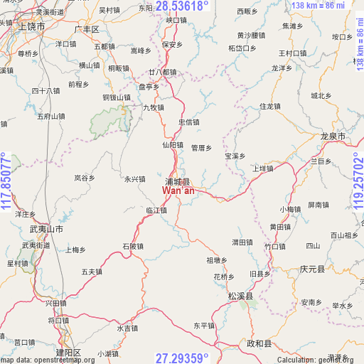
Wan’an GPS coordinates[2]
27° 55' 0.012" North, 118° 33' 14.004" East
| Map corner | latitude | longitude |
|---|---|---|
| Upper-left | 28.53618°, | 117.85077° |
| Center: | 27.91667°, | 118.55389° |
| Lower-right: | 27.29359°, | 119.25702° |
| Map W x H: | 138.2×138.2 km | = 85.9×85.9mi |
| max Lat: | 53.31946° ⇑74.6% North |
| Wan’an: | 27.91667° |
| min Lat: | ⇓25.4% South 18.22056° |
| min Long | Wan’an | max Long |
| 75.07348° | 118.55389° | 134.28917° |
| W 73.6%⇐ | ⇒26.4% E |
Elevation
Elevation of Wan’an is 257 m = 843 ft, and this is 227.8 m = 747 ft below average elevation for this country.
| Max E: |
5622 m = 18445 ft | 40.2% |
| Avg. | 484.8 m = 1591 ft | |
| Wan’an | 257 m = 843 ft | |
Min E: |
-3 m = -10 ft | 59.8% |
See also: China elevation on elevation.city.
Geographical zone
Wan’an is located in North temperate zone (between Tropic of Cancer and the Arctic Circle). Distance of this Northern Tropic circle is 498.1 km =309.5 mi to South.| Distance of | km | miles | from Wan’an |
|---|---|---|---|
| North Pole | 6903 | 4289.3 | to North |
| Arctic Circle | 4297.1 | 2670.1 | to North |
| Tropic Cancer | 498.1 | 309.5 | to South |
| Equator | 3104 | 1928.7 | to South |


Nearby cities:
15 places around Wan’an: (largest is in red/bold)
• Badu
37.8 km =23.5 mi,  79°
79°
• Fuling
8.9 km =5.5 mi,  105°
105°
• Haocun
37.1 km =23.1 mi,  193°
193°
• Liantang
3.8 km =2.4 mi,  282°
282°
• Linjiang
14.1 km =8.8 mi,  223°
223°
• Pucheng
2.2 km =1.4 mi,  290°
290°
• Shangyang
31.1 km =19.3 mi, 80°
• Shanxia
28.1 km =17.5 mi,  242°
242°
• Shibei
30.9 km =19.2 mi, 218°
• Shuibeijie
24.8 km =15.4 mi,  176°
176°
• Weitian
32.2 km =20 mi,  134°
134°
• Xianyang
14.8 km =9.2 mi,  346°
346°
• Xidong
28.9 km =18 mi, 129°
• Yongxing
18.2 km =11.3 mi,  274°
274°
• Zudun
32.3 km =20.1 mi,  155°
155°
Sources, notices
• [Note1] Compared only with cities in China existing in our database
• [Src1] Map data: © OpenStreetMap contributors (CC-BY-SA)
• [Src2] Other city data from geonames.org with taken over terms of usage.
• [Src3] Geographical zone / Annual Mean Temperature by Robert A. Rohde @ Wikipedia
