Tanbei geodata
Tanbei (Henan) is a seat of a third-order administrative division; located in China in Asia/Shanghai (GMT+8) time zone. In our database, there are 1268 cities with bigger population. Compared to other cities in China, 75.2% of cities are located further ↓South; 57.9% of cities are located further →East and 56.6% of cities have higher elevation than Tanbei. Note1


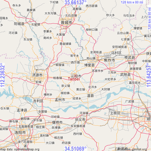
Tanbei GPS coordinates[2]
35° 5' 17.016" North, 112° 56' 21.984" East
| Map corner | latitude | longitude |
|---|---|---|
| Upper-left | 35.66137°, | 112.23632° |
| Center: | 35.08806°, | 112.93944° |
| Lower-right: | 34.51069°, | 113.64257° |
| Map W x H: | 127.9×127.9 km | = 79.5×79.5mi |
| max Lat: | 53.31946° ⇑24.8% North |
| Tanbei: | 35.08806° |
| min Lat: | ⇓75.2% South 18.22056° |
| min Long | Tanbei | max Long |
| 75.07348° | 112.93944° | 134.28917° |
| W 42.1%⇐ | ⇒57.9% E |
Elevation
Elevation of Tanbei is 120 m = 394 ft, and this is 364.8 m = 1197 ft below average elevation for this country.
| Max E: |
5622 m = 18445 ft | 56.6% |
| Avg. | 484.8 m = 1591 ft | |
| Tanbei | 120 m = 394 ft | |
Min E: |
-3 m = -10 ft | 43.4% |
See also: China elevation on elevation.city.
Geographical zone
Tanbei is located in North temperate zone (between Tropic of Cancer and the Arctic Circle). Distance of this Northern Tropic circle is 1295.5 km =805 mi to South.| Distance of | km | miles | from Tanbei |
|---|---|---|---|
| North Pole | 6105.6 | 3793.8 | to North |
| Arctic Circle | 3499.7 | 2174.6 | to North |
| Tropic Cancer | 1295.5 | 805 | to South |
| Equator | 3901.4 | 2424.2 | to South |


Nearby cities:
15 places around Tanbei: (largest is in red/bold)
• Changping
17 km =10.6 mi,  356°
356°
• Daqinglu
38.7 km =24 mi,  237°
237°
• Huichang
24.9 km =15.5 mi,  214°
214°
• Jiaozuo
31.6 km =19.6 mi,  57°
57°
• Jincun
46.1 km =28.6 mi, 356°
• Jiyuan
32.7 km =20.3 mi,  270°
270°
• Jiyuanlu
42 km =26.1 mi,  134°
134°
• Mucheng
41 km =25.5 mi,  88°
88°
• Nancun
43.7 km =27.2 mi,  342°
342°
• Qinghua
14 km =8.7 mi,  52°
52°
• Wenquan
20.9 km =13 mi,  144°
144°
• Xixiang
10.7 km =6.6 mi,  320°
320°
• Yanshi Chengguanzhen
43.4 km =27 mi,  197°
197°
• Zhongzhan
26.3 km =16.3 mi, 49°
• Zijinglu
36.6 km =22.7 mi,  175°
175°
Sources, notices
• [Note1] Compared only with cities in China existing in our database
• [Src1] Map data: © OpenStreetMap contributors (CC-BY-SA)
• [Src2] Other city data from geonames.org with taken over terms of usage.
• [Src3] Geographical zone / Annual Mean Temperature by Robert A. Rohde @ Wikipedia
