Moshi geodata
Moshi (Hunan) is a seat of a fourth-order administrative division; located in China in Asia/Shanghai (GMT+8) time zone. In our database, there are 1268 cities with bigger population. Compared to other cities in China, 56.7% of cities are located further ↑North; 67.2% of cities are located further →East and 50.4% of cities have lower elevation than Moshi. Note1


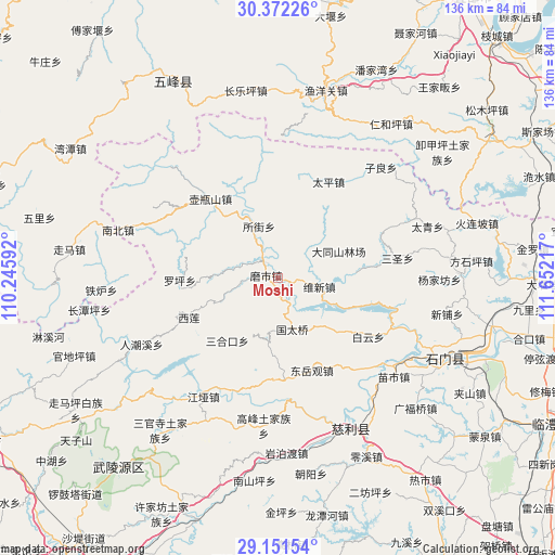
Moshi GPS coordinates[2]
29° 45' 49.536" North, 110° 56' 56.544" East
| Map corner | latitude | longitude |
|---|---|---|
| Upper-left | 30.37226°, | 110.24592° |
| Center: | 29.76376°, | 110.94904° |
| Lower-right: | 29.15154°, | 111.65217° |
| Map W x H: | 135.7×135.7 km | = 84.3×84.3mi |
| max Lat: | 53.31946° ⇑56.7% North |
| Moshi: | 29.76376° |
| min Lat: | ⇓43.3% South 18.22056° |
| min Long | Moshi | max Long |
| 75.07348° | 110.94904° | 134.28917° |
| W 32.8%⇐ | ⇒67.2% E |
Elevation
Elevation of Moshi is 168 m = 551 ft, and this is 316.8 m = 1039 ft below average elevation for this country.
| Max E: |
5622 m = 18445 ft | 49.6% |
| Avg. | 484.8 m = 1591 ft | |
| Moshi | 168 m = 551 ft | |
Min E: |
-3 m = -10 ft | 50.4% |
See also: China elevation on elevation.city.
Geographical zone
Moshi is located in North temperate zone (between Tropic of Cancer and the Arctic Circle). Distance of this Northern Tropic circle is 703.5 km =437.1 mi to South.| Distance of | km | miles | from Moshi |
|---|---|---|---|
| North Pole | 6697.6 | 4161.7 | to North |
| Arctic Circle | 4091.8 | 2542.5 | to North |
| Tropic Cancer | 703.5 | 437.1 | to South |
| Equator | 3309.4 | 2056.4 | to South |


Nearby cities:
15 places around Moshi: (largest is in red/bold)
• Baiyun
26.4 km =16.4 mi,  123°
123°
• Dongyueguan
24.1 km =15 mi,  159°
159°
• Luojiaping
24.2 km =15 mi,  267°
267°
• Nishi
25.2 km =15.7 mi,  319°
319°
• Sanhekou
19.4 km =12.1 mi,  218°
218°
• Sansheng
29.2 km =18.1 mi,  80°
80°
• Shanmuqiao
25.1 km =15.6 mi,  183°
183°
• Suojie
13.6 km =8.5 mi,  341°
341°
• Taiping
26.7 km =16.6 mi,  28°
28°
• Tongjinpu
25.1 km =15.6 mi, 176°
• Weixin
15.3 km =9.5 mi,  91°
91°
• Xilian
23.3 km =14.5 mi,  246°
246°
• Yanchi
4.4 km =2.7 mi,  334°
334°
• Yanliupu
27.7 km =17.2 mi,  141°
141°
• Zhuangta
15.8 km =9.8 mi,  197°
197°
Sources, notices
• [Note1] Compared only with cities in China existing in our database
• [Src1] Map data: © OpenStreetMap contributors (CC-BY-SA)
• [Src2] Other city data from geonames.org with taken over terms of usage.
• [Src3] Geographical zone / Annual Mean Temperature by Robert A. Rohde @ Wikipedia
