Sanhekou geodata
Sanhekou (Hunan) is a seat of a fourth-order administrative division; located in China in Asia/Shanghai (GMT+8) time zone. In our database, there are 1268 cities with bigger population. Compared to other cities in China, 58.3% of cities are located further ↑North; 67.8% of cities are located further →East and 80.2% of cities have lower elevation than Sanhekou. Note1


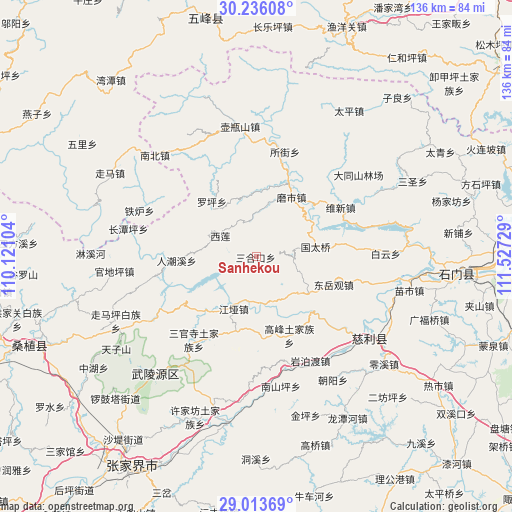
Sanhekou GPS coordinates[2]
29° 37' 36.264" North, 110° 49' 26.976" East
| Map corner | latitude | longitude |
|---|---|---|
| Upper-left | 30.23608°, | 110.12104° |
| Center: | 29.62674°, | 110.82416° |
| Lower-right: | 29.01369°, | 111.52729° |
| Map W x H: | 135.9×135.9 km | = 84.4×84.4mi |
| max Lat: | 53.31946° ⇑58.3% North |
| Sanhekou: | 29.62674° |
| min Lat: | ⇓41.7% South 18.22056° |
| min Long | Sanhekou | max Long |
| 75.07348° | 110.82416° | 134.28917° |
| W 32.2%⇐ | ⇒67.8% E |
Elevation
Elevation of Sanhekou is 706 m = 2316 ft, and this is 221.2 m = 726 ft above average elevation for this country.
| Max E: |
5622 m = 18445 ft | 19.8% |
| Sanhekou | 706 m 2316 ft | |
| Avg. | 484.8 m = 1591 ft | |
Min E: |
-3 m = -10 ft | 80.2% |
See also: China elevation on elevation.city.
Geographical zone
Sanhekou is located in North temperate zone (between Tropic of Cancer and the Arctic Circle). Distance of this Northern Tropic circle is 688.3 km =427.7 mi to South.| Distance of | km | miles | from Sanhekou |
|---|---|---|---|
| North Pole | 6712.9 | 4171.2 | to North |
| Arctic Circle | 4107 | 2552 | to North |
| Tropic Cancer | 688.3 | 427.7 | to South |
| Equator | 3294.2 | 2046.9 | to South |


Nearby cities:
15 places around Sanhekou: (largest is in red/bold)
• Baishi
24.6 km =15.3 mi,  290°
290°
• Dongyueguan
21.7 km =13.5 mi,  109°
109°
• Gaofeng
22.9 km =14.2 mi,  156°
156°
• Jiangya
14.8 km =9.2 mi,  203°
203°
• Luojiaping
18.7 km =11.6 mi,  319°
319°
• Moshi
19.4 km =12.1 mi,  38°
38°
• Renchaoxi
23.1 km =14.4 mi,  265°
265°
• Sanguansi
27.4 km =17 mi,  217°
217°
• Shanmuqiao
14.4 km =8.9 mi,  133°
133°
• Tongjinpu
16.9 km =10.5 mi, 125°
• Xiangshi
12.2 km =7.6 mi,  173°
173°
• Xilian
10.9 km =6.8 mi,  302°
302°
• Yanchi
21.7 km =13.5 mi,  28°
28°
• Zhaojiagang
20.3 km =12.6 mi, 224°
• Zhuangta
7.4 km =4.6 mi,  88°
88°
Sources, notices
• [Note1] Compared only with cities in China existing in our database
• [Src1] Map data: © OpenStreetMap contributors (CC-BY-SA)
• [Src2] Other city data from geonames.org with taken over terms of usage.
• [Src3] Geographical zone / Annual Mean Temperature by Robert A. Rohde @ Wikipedia
