Nishi geodata
Nishi (Hunan) is a seat of a fourth-order administrative division; located in China in Asia/Shanghai (GMT+8) time zone. In our database, there are 1268 cities with bigger population. Compared to other cities in China, 54.7% of cities are located further ↑North; 68% of cities are located further →East and 60.2% of cities have lower elevation than Nishi. Note1


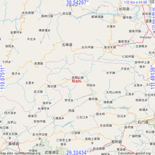
Nishi GPS coordinates[2]
29° 56' 7.872" North, 110° 46' 41.628" East
| Map corner | latitude | longitude |
|---|---|---|
| Upper-left | 30.54297°, | 110.07511° |
| Center: | 29.93552°, | 110.77823° |
| Lower-right: | 29.32434°, | 111.48136° |
| Map W x H: | 135.5×135.5 km | = 84.2×84.2mi |
| max Lat: | 53.31946° ⇑54.7% North |
| Nishi: | 29.93552° |
| min Lat: | ⇓45.3% South 18.22056° |
| min Long | Nishi | max Long |
| 75.07348° | 110.77823° | 134.28917° |
| W 32%⇐ | ⇒68% E |
Elevation
Elevation of Nishi is 262 m = 860 ft, and this is 222.8 m = 731 ft below average elevation for this country.
| Max E: |
5622 m = 18445 ft | 39.8% |
| Avg. | 484.8 m = 1591 ft | |
| Nishi | 262 m = 860 ft | |
Min E: |
-3 m = -10 ft | 60.2% |
See also: China elevation on elevation.city.
Geographical zone
Nishi is located in North temperate zone (between Tropic of Cancer and the Arctic Circle). Distance of this Northern Tropic circle is 722.6 km =449 mi to South.| Distance of | km | miles | from Nishi |
|---|---|---|---|
| North Pole | 6678.5 | 4149.8 | to North |
| Arctic Circle | 4072.7 | 2530.7 | to North |
| Tropic Cancer | 722.6 | 449 | to South |
| Equator | 3328.5 | 2068.2 | to South |


Nearby cities:
15 places around Nishi: (largest is in red/bold)
• Baiguo
31.6 km =19.6 mi,  259°
259°
• Baishi
31.8 km =19.8 mi,  215°
215°
• Changleping
28 km =17.4 mi,  17°
17°
• Luojiaping
21.5 km =13.4 mi,  200°
200°
• Moshi
25.2 km =15.7 mi,  139°
139°
• Nanzhen
23.2 km =14.4 mi,  252°
252°
• Sanhekou
34.6 km =21.5 mi,  172°
172°
• Suojie
13.7 km =8.5 mi,  116°
116°
• Taiping
29.4 km =18.3 mi,  81°
81°
• Wufeng
30.6 km =19 mi,  344°
344°
• Xilian
28.9 km =18 mi,  189°
189°
• Yanchi
21.1 km =13.1 mi, 136°
• Zhuangta
36.2 km =22.5 mi,  160°
160°
• Zhujiatai
34.3 km =21.3 mi,  230°
230°
• Zouma
36.3 km =22.6 mi, 250°
Sources, notices
• [Note1] Compared only with cities in China existing in our database
• [Src1] Map data: © OpenStreetMap contributors (CC-BY-SA)
• [Src2] Other city data from geonames.org with taken over terms of usage.
• [Src3] Geographical zone / Annual Mean Temperature by Robert A. Rohde @ Wikipedia
