Tongjinpu geodata
Tongjinpu (Hunan) is a seat of a fourth-order administrative division; located in China in Asia/Shanghai (GMT+8) time zone. In our database, there are 1268 cities with bigger population. Compared to other cities in China, 59.3% of cities are located further ↑North; 67.1% of cities are located further →East and 51.6% of cities have higher elevation than Tongjinpu. Note1


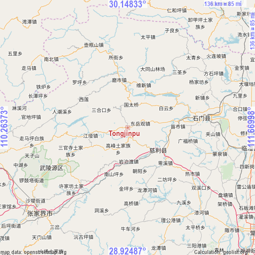
Tongjinpu GPS coordinates[2]
29° 32' 18.42" North, 110° 58' 0.66" East
| Map corner | latitude | longitude |
|---|---|---|
| Upper-left | 30.14833°, | 110.26373° |
| Center: | 29.53845°, | 110.96685° |
| Lower-right: | 28.92487°, | 111.66998° |
| Map W x H: | 136×136 km | = 84.5×84.5mi |
| max Lat: | 53.31946° ⇑59.3% North |
| Tongjinpu: | 29.53845° |
| min Lat: | ⇓40.7% South 18.22056° |
| min Long | Tongjinpu | max Long |
| 75.07348° | 110.96685° | 134.28917° |
| W 32.9%⇐ | ⇒67.1% E |
Elevation
Elevation of Tongjinpu is 152 m = 499 ft, and this is 332.8 m = 1092 ft below average elevation for this country.
| Max E: |
5622 m = 18445 ft | 51.6% |
| Avg. | 484.8 m = 1591 ft | |
| Tongjinpu | 152 m = 499 ft | |
Min E: |
-3 m = -10 ft | 48.4% |
See also: China elevation on elevation.city.
Geographical zone
Tongjinpu is located in North temperate zone (between Tropic of Cancer and the Arctic Circle). Distance of this Northern Tropic circle is 678.4 km =421.5 mi to South.| Distance of | km | miles | from Tongjinpu |
|---|---|---|---|
| North Pole | 6722.7 | 4177.3 | to North |
| Arctic Circle | 4116.8 | 2558.1 | to North |
| Tropic Cancer | 678.4 | 421.5 | to South |
| Equator | 3284.4 | 2040.8 | to South |


Nearby cities:
15 places around Tongjinpu: (largest is in red/bold)
• Baiyun
23 km =14.3 mi,  62°
62°
• Chaoyang
23.4 km =14.5 mi,  164°
164°
• Cili
19.5 km =12.1 mi,  130°
130°
• Dongyueguan
7.1 km =4.4 mi,  70°
70°
• Gaofeng
12.3 km =7.6 mi,  203°
203°
• Jiangya
20 km =12.4 mi,  259°
259°
• Moshi
25.1 km =15.6 mi,  356°
356°
• Nanshanping
25.6 km =15.9 mi, 195°
• Sanhekou
16.9 km =10.5 mi,  305°
305°
• Shanmuqiao
3.4 km =2.1 mi,  269°
269°
• Xiangshi
12.7 km =7.9 mi, 259°
• Yanbodu
18.2 km =11.3 mi,  179°
179°
• Yanliupu
16 km =9.9 mi,  77°
77°
• Yichongqiao
25.2 km =15.7 mi, 203°
• Zhuangta
11.8 km =7.3 mi,  327°
327°
Sources, notices
• [Note1] Compared only with cities in China existing in our database
• [Src1] Map data: © OpenStreetMap contributors (CC-BY-SA)
• [Src2] Other city data from geonames.org with taken over terms of usage.
• [Src3] Geographical zone / Annual Mean Temperature by Robert A. Rohde @ Wikipedia
