Moping geodata
Moping (Hubei) is a seat of a fourth-order administrative division; located in China in Asia/Shanghai (GMT+8) time zone. In our database, there are 1268 cities with bigger population. Compared to other cities in China, 53% of cities are located further ↓South; 69.4% of cities are located further →East and 86.2% of cities have lower elevation than Moping. Note1


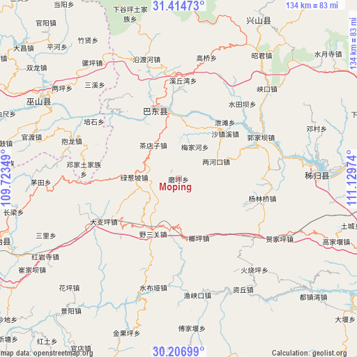
Moping GPS coordinates[2]
30° 48' 45.936" North, 110° 25' 35.796" East
| Map corner | latitude | longitude |
|---|---|---|
| Upper-left | 31.41473°, | 109.72349° |
| Center: | 30.81276°, | 110.42661° |
| Lower-right: | 30.20699°, | 111.12974° |
| Map W x H: | 134.3×134.3 km | = 83.5×83.5mi |
| max Lat: | 53.31946° ⇑47% North |
| Moping: | 30.81276° |
| min Lat: | ⇓53% South 18.22056° |
| min Long | Moping | max Long |
| 75.07348° | 110.42661° | 134.28917° |
| W 30.6%⇐ | ⇒69.4% E |
Elevation
Elevation of Moping is 1055 m = 3461 ft, and this is 570.2 m = 1871 ft above average elevation for this country.
| Max E: |
5622 m = 18445 ft | 13.8% |
| Moping | 1055 m 3461 ft | |
| Avg. | 484.8 m = 1591 ft | |
Min E: |
-3 m = -10 ft | 86.2% |
See also: China elevation on elevation.city.
Geographical zone
Moping is located in North temperate zone (between Tropic of Cancer and the Arctic Circle). Distance of this Northern Tropic circle is 820.1 km =509.6 mi to South.| Distance of | km | miles | from Moping |
|---|---|---|---|
| North Pole | 6581 | 4089.2 | to North |
| Arctic Circle | 3975.1 | 2470 | to North |
| Tropic Cancer | 820.1 | 509.6 | to South |
| Equator | 3426.1 | 2128.9 | to South |


Nearby cities:
15 places around Moping: (largest is in red/bold)
• Chadianzi
15.9 km =9.9 mi,  323°
323°
• Dazhiping
32.4 km =20.1 mi,  240°
240°
• Guandukou
27.6 km =17.1 mi,  335°
335°
• Guizhou
32.4 km =20.1 mi,  50°
50°
• Guojiaba
31.3 km =19.4 mi,  67°
67°
• Langping
23.5 km =14.6 mi,  160°
160°
• Lianghekou
15.6 km =9.7 mi,  64°
64°
• Longping
26.5 km =16.5 mi,  270°
270°
• Lücongpo
16.6 km =10.3 mi, 272°
• Meijiahe
13.1 km =8.1 mi,  25°
25°
• Shazhenxi
23.2 km =14.4 mi, 45°
• Xietan
28.6 km =17.8 mi,  39°
39°
• Xinling
25.8 km =16 mi, 336°
• Yanglinqiao
32.5 km =20.2 mi,  102°
102°
• Yesanguan
23.7 km =14.7 mi,  204°
204°
Sources, notices
• [Note1] Compared only with cities in China existing in our database
• [Src1] Map data: © OpenStreetMap contributors (CC-BY-SA)
• [Src2] Other city data from geonames.org with taken over terms of usage.
• [Src3] Geographical zone / Annual Mean Temperature by Robert A. Rohde @ Wikipedia
