Lücongpo geodata
Lücongpo (Hubei) is a seat of a fourth-order administrative division; located in China in Asia/Shanghai (GMT+8) time zone. In our database, there are 1268 cities with bigger population. Compared to other cities in China, 53.1% of cities are located further ↓South; 70.2% of cities are located further →East and 92.7% of cities have lower elevation than Lücongpo. Note1


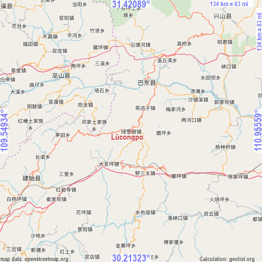
Lücongpo GPS coordinates[2]
30° 49' 8.256" North, 110° 15' 8.856" East
| Map corner | latitude | longitude |
|---|---|---|
| Upper-left | 31.42089°, | 109.54934° |
| Center: | 30.81896°, | 110.25246° |
| Lower-right: | 30.21323°, | 110.95559° |
| Map W x H: | 134.3×134.3 km | = 83.5×83.5mi |
| max Lat: | 53.31946° ⇑46.9% North |
| Lücongpo: | 30.81896° |
| min Lat: | ⇓53.1% South 18.22056° |
| min Long | Lücongpo | max Long |
| 75.07348° | 110.25246° | 134.28917° |
| W 29.8%⇐ | ⇒70.2% E |
Elevation
Elevation of Lücongpo is 1672 m = 5486 ft, and this is 1187.2 m = 3895 ft above average elevation for this country.
| Max E: |
5622 m = 18445 ft | 7.3% |
| Lücongpo | 1672 m 5486 ft | |
| Avg. | 484.8 m = 1591 ft | |
Min E: |
-3 m = -10 ft | 92.7% |
See also: China elevation on elevation.city.
Geographical zone
Lücongpo is located in North temperate zone (between Tropic of Cancer and the Arctic Circle). Distance of this Northern Tropic circle is 820.8 km =510 mi to South.| Distance of | km | miles | from Lücongpo |
|---|---|---|---|
| North Pole | 6580.3 | 4088.8 | to North |
| Arctic Circle | 3974.4 | 2469.6 | to North |
| Tropic Cancer | 820.8 | 510 | to South |
| Equator | 3426.7 | 2129.3 | to South |


Nearby cities:
15 places around Lücongpo: (largest is in red/bold)
• Baolong
27.2 km =16.9 mi,  300°
300°
• Chadianzi
14 km =8.7 mi,  30°
30°
• Dazhiping
20.2 km =12.6 mi,  214°
214°
• Duping
18.9 km =11.7 mi,  311°
311°
• Gaoping
23.9 km =14.9 mi,  223°
223°
• Guandukou
25.1 km =15.6 mi,  12°
12°
• Langping
33.4 km =20.8 mi,  133°
133°
• Lianghekou
31.4 km =19.5 mi,  79°
79°
• Longping
9.9 km =6.2 mi,  266°
266°
• Maotian
35.2 km =21.9 mi, 267°
• Meijiahe
24.9 km =15.5 mi,  63°
63°
• Moping
16.6 km =10.3 mi,  92°
92°
• Shazhenxi
36.7 km =22.8 mi,  65°
65°
• Xinling
23.8 km =14.8 mi,  15°
15°
• Yesanguan
23.3 km =14.5 mi,  163°
163°
Sources, notices
• [Note1] Compared only with cities in China existing in our database
• [Src1] Map data: © OpenStreetMap contributors (CC-BY-SA)
• [Src2] Other city data from geonames.org with taken over terms of usage.
• [Src3] Geographical zone / Annual Mean Temperature by Robert A. Rohde @ Wikipedia
