Guandukou geodata
Guandukou (Hubei) is a seat of a fourth-order administrative division; located in China in Asia/Shanghai (GMT+8) time zone. In our database, there are 1268 cities with bigger population. Compared to other cities in China, 55.2% of cities are located further ↓South; 70% of cities are located further →East and 57.1% of cities have higher elevation than Guandukou. Note1


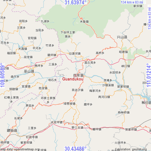
Guandukou GPS coordinates[2]
31° 2' 21.156" North, 110° 18' 32.436" East
| Map corner | latitude | longitude |
|---|---|---|
| Upper-left | 31.63974°, | 109.60589° |
| Center: | 31.03921°, | 110.30901° |
| Lower-right: | 30.43486°, | 111.01214° |
| Map W x H: | 134×134 km | = 83.3×83.3mi |
| max Lat: | 53.31946° ⇑44.8% North |
| Guandukou: | 31.03921° |
| min Lat: | ⇓55.2% South 18.22056° |
| min Long | Guandukou | max Long |
| 75.07348° | 110.30901° | 134.28917° |
| W 30%⇐ | ⇒70% E |
Elevation
Elevation of Guandukou is 117 m = 384 ft, and this is 367.8 m = 1207 ft below average elevation for this country.
| Max E: |
5622 m = 18445 ft | 57.1% |
| Avg. | 484.8 m = 1591 ft | |
| Guandukou | 117 m = 384 ft | |
Min E: |
-3 m = -10 ft | 42.9% |
See also: China elevation on elevation.city.
Geographical zone
Guandukou is located in North temperate zone (between Tropic of Cancer and the Arctic Circle). Distance of this Northern Tropic circle is 845.3 km =525.2 mi to South.| Distance of | km | miles | from Guandukou |
|---|---|---|---|
| North Pole | 6555.8 | 4073.6 | to North |
| Arctic Circle | 3949.9 | 2454.4 | to North |
| Tropic Cancer | 845.3 | 525.2 | to South |
| Equator | 3451.2 | 2144.5 | to South |


Nearby cities:
15 places around Guandukou: (largest is in red/bold)
• Baolong
30.8 km =19.1 mi,  249°
249°
• Chadianzi
12.5 km =7.8 mi,  172°
172°
• Duping
22.9 km =14.2 mi,  238°
238°
• Gaoqiao
30.7 km =19.1 mi,  46°
46°
• Longping
29.3 km =18.2 mi,  211°
211°
• Luoping
28.2 km =17.5 mi,  311°
311°
• Lücongpo
25.1 km =15.6 mi,  192°
192°
• Meijiahe
21.5 km =13.4 mi,  128°
128°
• Moping
27.6 km =17.1 mi,  155°
155°
• Sanxi
22.9 km =14.2 mi,  296°
296°
• Shazhenxi
29.3 km =18.2 mi,  107°
107°
• Xietan
29.6 km =18.4 mi,  96°
96°
• Xinling
1.8 km =1.1 mi,  150°
150°
• Xiqiuwan
17.3 km =10.7 mi, 47°
• Yanduhe
20.8 km =12.9 mi,  355°
355°
Sources, notices
• [Note1] Compared only with cities in China existing in our database
• [Src1] Map data: © OpenStreetMap contributors (CC-BY-SA)
• [Src2] Other city data from geonames.org with taken over terms of usage.
• [Src3] Geographical zone / Annual Mean Temperature by Robert A. Rohde @ Wikipedia
