Maying geodata
Maying (Shanxi) is a seat of a fourth-order administrative division; located in China in Asia/Shanghai (GMT+8) time zone. In our database, there are 1268 cities with bigger population. Compared to other cities in China, 85.4% of cities are located further ↓South; 59% of cities are located further →East and 91.6% of cities have lower elevation than Maying. Note1


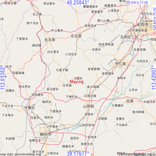
Maying GPS coordinates[2]
39° 43' 10.992" North, 112° 43' 0.984" East
| Map corner | latitude | longitude |
|---|---|---|
| Upper-left | 40.25843°, | 112.01382° |
| Center: | 39.71972°, | 112.71694° |
| Lower-right: | 39.17677°, | 113.42007° |
| Map W x H: | 120.3×120.3 km | = 74.8×74.8mi |
| max Lat: | 53.31946° ⇑14.6% North |
| Maying: | 39.71972° |
| min Lat: | ⇓85.4% South 18.22056° |
| min Long | Maying | max Long |
| 75.07348° | 112.71694° | 134.28917° |
| W 41%⇐ | ⇒59% E |
Elevation
Elevation of Maying is 1534 m = 5033 ft, and this is 1049.2 m = 3442 ft above average elevation for this country.
| Max E: |
5622 m = 18445 ft | 8.4% |
| Maying | 1534 m 5033 ft | |
| Avg. | 484.8 m = 1591 ft | |
Min E: |
-3 m = -10 ft | 91.6% |
See also: China elevation on elevation.city.
Geographical zone
Maying is located in North temperate zone (between Tropic of Cancer and the Arctic Circle). Distance of this Northern Tropic circle is 1810.5 km =1125 mi to South.| Distance of | km | miles | from Maying |
|---|---|---|---|
| North Pole | 5590.6 | 3473.8 | to North |
| Arctic Circle | 2984.8 | 1854.7 | to North |
| Tropic Cancer | 1810.5 | 1125 | to South |
| Equator | 4416.4 | 2744.2 | to South |


Nearby cities:
15 places around Maying: (largest is in red/bold)
• Anrong
29 km =18 mi,  163°
163°
• Baitouli
28.1 km =17.5 mi,  316°
316°
• Beizhouzhuang
16.3 km =10.1 mi,  146°
146°
• Daiyue
23.8 km =14.8 mi, 158°
• Gaojiabu
24.5 km =15.2 mi,  289°
289°
• Heshengbao
22.8 km =14.2 mi,  134°
134°
• Madaotou
17.9 km =11.1 mi,  14°
14°
• Shuiyao
25 km =15.5 mi,  33°
33°
• Wujiayao
13.9 km =8.6 mi,  58°
58°
• Wumaying
21.5 km =13.4 mi,  247°
247°
• Xialaba
15.1 km =9.4 mi,  199°
199°
• Xiaojingzhuang
19.4 km =12.1 mi,  343°
343°
• Xinjiayuan
23.3 km =14.5 mi,  80°
80°
• Yuanbuzi
19.3 km =12 mi,  306°
306°
• Yujing
10.9 km =6.8 mi,  243°
243°
Sources, notices
• [Note1] Compared only with cities in China existing in our database
• [Src1] Map data: © OpenStreetMap contributors (CC-BY-SA)
• [Src2] Other city data from geonames.org with taken over terms of usage.
• [Src3] Geographical zone / Annual Mean Temperature by Robert A. Rohde @ Wikipedia
