Wujiayao geodata
Wujiayao (Shanxi) is a seat of a fourth-order administrative division; located in China in Asia/Shanghai (GMT+8) time zone. In our database, there are 1268 cities with bigger population. Compared to other cities in China, 85.6% of cities are located further ↓South; 58.4% of cities are located further →East and 89.1% of cities have lower elevation than Wujiayao. Note1


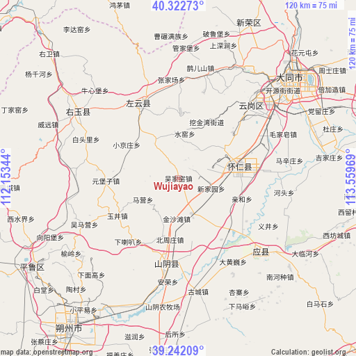
Wujiayao GPS coordinates[2]
39° 47' 4.308" North, 112° 51' 23.616" East
| Map corner | latitude | longitude |
|---|---|---|
| Upper-left | 40.32273°, | 112.15344° |
| Center: | 39.78453°, | 112.85656° |
| Lower-right: | 39.24209°, | 113.55969° |
| Map W x H: | 120.2×120.2 km | = 74.7×74.7mi |
| max Lat: | 53.31946° ⇑14.4% North |
| Wujiayao: | 39.78453° |
| min Lat: | ⇓85.6% South 18.22056° |
| min Long | Wujiayao | max Long |
| 75.07348° | 112.85656° | 134.28917° |
| W 41.6%⇐ | ⇒58.4% E |
Elevation
Elevation of Wujiayao is 1277 m = 4190 ft, and this is 792.2 m = 2599 ft above average elevation for this country.
| Max E: |
5622 m = 18445 ft | 10.9% |
| Wujiayao | 1277 m 4190 ft | |
| Avg. | 484.8 m = 1591 ft | |
Min E: |
-3 m = -10 ft | 89.1% |
See also: China elevation on elevation.city.
Geographical zone
Wujiayao is located in North temperate zone (between Tropic of Cancer and the Arctic Circle). Distance of this Northern Tropic circle is 1817.7 km =1129.5 mi to South.| Distance of | km | miles | from Wujiayao |
|---|---|---|---|
| North Pole | 5583.4 | 3469.4 | to North |
| Arctic Circle | 2977.5 | 1850.1 | to North |
| Tropic Cancer | 1817.7 | 1129.5 | to South |
| Equator | 4423.6 | 2748.7 | to South |


Nearby cities:
15 places around Wujiayao: (largest is in red/bold)
• Beizhouzhuang
20.9 km =13 mi,  187°
187°
• Dianwan
22.5 km =14 mi,  1°
1°
• Hejiabao
16.8 km =10.4 mi,  78°
78°
• Heshengbao
23.6 km =14.7 mi,  169°
169°
• Madaotou
12.7 km =7.9 mi,  323°
323°
• Maying
13.9 km =8.6 mi,  238°
238°
• Qingshuihe
22.6 km =14 mi,  107°
107°
• Shuiyao
13.7 km =8.5 mi,  8°
8°
• Xialaba
27.3 km =17 mi,  218°
218°
• Xiaojingzhuang
20.8 km =12.9 mi,  302°
302°
• Xinjiayuan
11.6 km =7.2 mi, 107°
• Ya’erya
23.6 km =14.7 mi,  29°
29°
• Yujing
24.8 km =15.4 mi, 240°
• Yunxing
27.4 km =17 mi,  330°
330°
• Yunzhong
21 km =13 mi, 76°
Sources, notices
• [Note1] Compared only with cities in China existing in our database
• [Src1] Map data: © OpenStreetMap contributors (CC-BY-SA)
• [Src2] Other city data from geonames.org with taken over terms of usage.
• [Src3] Geographical zone / Annual Mean Temperature by Robert A. Rohde @ Wikipedia
