Daiyue geodata
Daiyue (Shanxi) is a seat of a third-order administrative division; located in China in Asia/Shanghai (GMT+8) time zone. In our database, there are 1268 cities with bigger population. Compared to other cities in China, 84.7% of cities are located further ↓South; 58.6% of cities are located further →East and 86.2% of cities have lower elevation than Daiyue. Note1


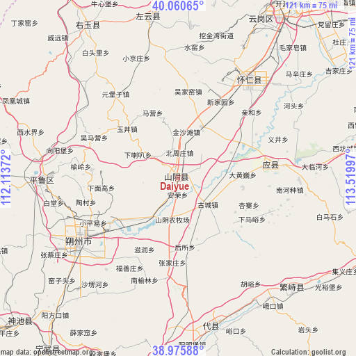
Daiyue GPS coordinates[2]
39° 31' 13.368" North, 112° 49' 0.624" East
| Map corner | latitude | longitude |
|---|---|---|
| Upper-left | 40.06065°, | 112.11372° |
| Center: | 39.52038°, | 112.81684° |
| Lower-right: | 38.97588°, | 113.51997° |
| Map W x H: | 120.6×120.6 km | = 74.9×74.9mi |
| max Lat: | 53.31946° ⇑15.3% North |
| Daiyue: | 39.52038° |
| min Lat: | ⇓84.7% South 18.22056° |
| min Long | Daiyue | max Long |
| 75.07348° | 112.81684° | 134.28917° |
| W 41.4%⇐ | ⇒58.6% E |
Elevation
Elevation of Daiyue is 1054 m = 3458 ft, and this is 569.2 m = 1867 ft above average elevation for this country.
| Max E: |
5622 m = 18445 ft | 13.8% |
| Daiyue | 1054 m 3458 ft | |
| Avg. | 484.8 m = 1591 ft | |
Min E: |
-3 m = -10 ft | 86.2% |
See also: China elevation on elevation.city.
Geographical zone
Daiyue is located in North temperate zone (between Tropic of Cancer and the Arctic Circle). Distance of this Northern Tropic circle is 1788.3 km =1111.2 mi to South.| Distance of | km | miles | from Daiyue |
|---|---|---|---|
| North Pole | 5612.8 | 3487.6 | to North |
| Arctic Circle | 3006.9 | 1868.4 | to North |
| Tropic Cancer | 1788.3 | 1111.2 | to South |
| Equator | 4394.3 | 2730.5 | to South |


Nearby cities:
15 places around Daiyue: (largest is in red/bold)
• Anrong
5.6 km =3.5 mi,  181°
181°
• Beizhouzhuang
8.7 km =5.4 mi,  3°
3°
• Dahuangwei
21.9 km =13.6 mi,  86°
86°
• Dongshentou
25.1 km =15.6 mi,  233°
233°
• Gucheng
13.4 km =8.3 mi,  131°
131°
• Heshengbao
9.8 km =6.1 mi,  51°
51°
• Housuo
23.4 km =14.5 mi,  174°
174°
• Maying
23.8 km =14.8 mi,  338°
338°
• Mayingzhuang
22.2 km =13.8 mi,  139°
139°
• Xialaba
15.8 km =9.8 mi,  300°
300°
• Xiamiangao
26.2 km =16.3 mi,  264°
264°
• Xuekulue
12.6 km =7.8 mi,  187°
187°
• Yujing
25.2 km =15.7 mi,  313°
313°
• Zangzhai
28.2 km =17.5 mi,  64°
64°
• Zirun
26.7 km =16.6 mi,  205°
205°
Sources, notices
• [Note1] Compared only with cities in China existing in our database
• [Src1] Map data: © OpenStreetMap contributors (CC-BY-SA)
• [Src2] Other city data from geonames.org with taken over terms of usage.
• [Src3] Geographical zone / Annual Mean Temperature by Robert A. Rohde @ Wikipedia
