Maoba geodata
Maoba (Hubei) is a seat of a fourth-order administrative division; located in China in Asia/Shanghai (GMT+8) time zone. In our database, there are 1268 cities with bigger population. Compared to other cities in China, 53.7% of cities are located further ↑North; 76.1% of cities are located further →East and 80.1% of cities have lower elevation than Maoba. Note1


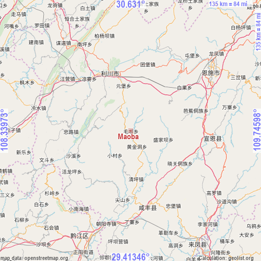
Maoba GPS coordinates[2]
30° 1' 26.76" North, 109° 2' 34.26" East
| Map corner | latitude | longitude |
|---|---|---|
| Upper-left | 30.631°, | 108.33973° |
| Center: | 30.0241°, | 109.04285° |
| Lower-right: | 29.41346°, | 109.74598° |
| Map W x H: | 135.4×135.4 km | = 84.1×84.1mi |
| max Lat: | 53.31946° ⇑53.7% North |
| Maoba: | 30.0241° |
| min Lat: | ⇓46.3% South 18.22056° |
| min Long | Maoba | max Long |
| 75.07348° | 109.04285° | 134.28917° |
| W 23.9%⇐ | ⇒76.1% E |
Elevation
Elevation of Maoba is 701 m = 2300 ft, and this is 216.2 m = 709 ft above average elevation for this country.
| Max E: |
5622 m = 18445 ft | 19.9% |
| Maoba | 701 m 2300 ft | |
| Avg. | 484.8 m = 1591 ft | |
Min E: |
-3 m = -10 ft | 80.1% |
See also: China elevation on elevation.city.
Geographical zone
Maoba is located in North temperate zone (between Tropic of Cancer and the Arctic Circle). Distance of this Northern Tropic circle is 732.4 km =455.1 mi to South.| Distance of | km | miles | from Maoba |
|---|---|---|---|
| North Pole | 6668.7 | 4143.7 | to North |
| Arctic Circle | 4062.8 | 2524.5 | to North |
| Tropic Cancer | 732.4 | 455.1 | to South |
| Equator | 3338.4 | 2074.4 | to South |


Nearby cities:
15 places around Maoba: (largest is in red/bold)
• Baiguo
35.9 km =22.3 mi,  50°
50°
• Huangjindong
8.7 km =5.4 mi,  157°
157°
• Huolongping
37.1 km =23.1 mi,  235°
235°
• Jianshan
36 km =22.4 mi,  186°
186°
• Jiaoyuan
38.4 km =23.9 mi,  90°
90°
• Liangwu
34.6 km =21.5 mi,  321°
321°
• Lichuan
35.8 km =22.2 mi,  328°
328°
• Qingshuitang
25.3 km =15.7 mi,  174°
174°
• Shaxi
32.2 km =20 mi,  246°
246°
• Shengjiaba
17.5 km =10.9 mi,  104°
104°
• Tuanbao
35.9 km =22.3 mi,  14°
14°
• Xiaocun
15 km =9.3 mi,  213°
213°
• Xiaoguan
31.3 km =19.4 mi,  121°
121°
• Yuanbao
23.8 km =14.8 mi,  351°
351°
• Zhonglu
31.1 km =19.3 mi,  269°
269°
Sources, notices
• [Note1] Compared only with cities in China existing in our database
• [Src1] Map data: © OpenStreetMap contributors (CC-BY-SA)
• [Src2] Other city data from geonames.org with taken over terms of usage.
• [Src3] Geographical zone / Annual Mean Temperature by Robert A. Rohde @ Wikipedia
