Lichuan geodata
Lichuan (Hubei) is a populated place; located in China in Asia/Shanghai (GMT+8) time zone. With population of 72,653 people, there are 590 cities with bigger population in this country. Compared to other cities in China, 51.2% of cities are located further ↑North; 77% of cities are located further →East and 88.8% of cities have lower elevation than Lichuan. Note1


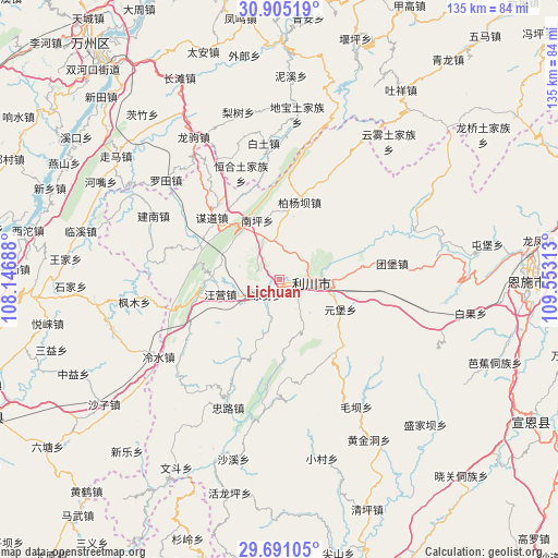
Lichuan GPS coordinates[2]
30° 18' 0" North, 108° 51' 0" East
| Map corner | latitude | longitude |
|---|---|---|
| Upper-left | 30.90519°, | 108.14688° |
| Center: | 30.3°, | 108.85° |
| Lower-right: | 29.69105°, | 109.55313° |
| Map W x H: | 135×135 km | = 83.9×83.9mi |
| max Lat: | 53.31946° ⇑51.2% North |
| Lichuan: | 30.3° |
| min Lat: | ⇓48.8% South 18.22056° |
| min Long | Lichuan | max Long |
| 75.07348° | 108.85° | 134.28917° |
| W 23%⇐ | ⇒77% E |
Elevation
Elevation of Lichuan is 1255 m = 4117 ft, and this is 770.2 m = 2527 ft above average elevation for this country.
| Max E: |
5622 m = 18445 ft | 11.2% |
| Lichuan | 1255 m 4117 ft | |
| Avg. | 484.8 m = 1591 ft | |
Min E: |
-3 m = -10 ft | 88.8% |
See also: Lichuan elevation on elevation.city.
Geographical zone
Lichuan is located in North temperate zone (between Tropic of Cancer and the Arctic Circle). Distance of this Northern Tropic circle is 763.1 km =474.2 mi to South.| Distance of | km | miles | from Lichuan |
|---|---|---|---|
| North Pole | 6638 | 4124.7 | to North |
| Arctic Circle | 4032.1 | 2505.4 | to North |
| Tropic Cancer | 763.1 | 474.2 | to South |
| Equator | 3369 | 2093.4 | to South |


Nearby cities:
15 places around Lichuan: (largest is in red/bold)
• Baitu
33.3 km =20.7 mi,  353°
353°
• Baiyang
19.9 km =12.4 mi,  14°
14°
• Fengmu
35.7 km =22.2 mi,  260°
260°
• Henghe
27.3 km =17 mi,  340°
340°
• Jiannan
34 km =21.1 mi,  297°
297°
• Lengshui
34.8 km =21.6 mi,  237°
237°
• Liangwu
4.6 km =2.9 mi,  218°
218°
• Luotian
36.8 km =22.9 mi,  310°
310°
• Maoba
35.8 km =22.2 mi,  148°
148°
• Moudao
22.3 km =13.9 mi, 312°
• Nanping
15.5 km =9.6 mi, 339°
• Tuanbao
27.6 km =17.1 mi,  81°
81°
• Wangying
15.3 km =9.5 mi, 258°
• Yuanbao
16.5 km =10.3 mi,  115°
115°
• Zhonglu
33.3 km =20.7 mi,  202°
202°
Sources, notices
• [Note1] Compared only with cities in China existing in our database
• [Src1] Map data: © OpenStreetMap contributors (CC-BY-SA)
• [Src2] Other city data from geonames.org with taken over terms of usage.
• [Src3] Geographical zone / Annual Mean Temperature by Robert A. Rohde @ Wikipedia
