Yuanbao geodata
Yuanbao (Hubei) is a seat of a fourth-order administrative division; located in China in Asia/Shanghai (GMT+8) time zone. In our database, there are 1268 cities with bigger population. Compared to other cities in China, 51.8% of cities are located further ↑North; 76.3% of cities are located further →East and 87% of cities have lower elevation than Yuanbao. Note1


Yuanbao GPS coordinates[2]
30° 14' 9.168" North, 109° 0' 18.504" East
| Map corner | latitude | longitude |
|---|---|---|
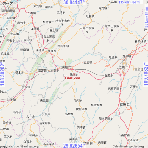
| Upper-left | 30.84147°, | 108.30202° |
| Center: | 30.23588°, | 109.00514° |
| Lower-right: | 29.62654°, | 109.70827° |
| Map W x H: | 135.1×135.1 km | = 83.9×83.9mi |
| max Lat: | 53.31946° ⇑51.8% North |
| Yuanbao: | 30.23588° |
| min Lat: | ⇓48.2% South 18.22056° |
| min Long | Yuanbao | max Long |
| 75.07348° | 109.00514° | 134.28917° |
| W 23.7%⇐ | ⇒76.3% E |
Elevation
Elevation of Yuanbao is 1116 m = 3661 ft, and this is 631.2 m = 2071 ft above average elevation for this country.
| Max E: |
5622 m = 18445 ft | 13% |
| Yuanbao | 1116 m 3661 ft | |
| Avg. | 484.8 m = 1591 ft | |
Min E: |
-3 m = -10 ft | 87% |
See also: China elevation on elevation.city.
Geographical zone
Yuanbao is located in North temperate zone (between Tropic of Cancer and the Arctic Circle). Distance of this Northern Tropic circle is 756 km =469.8 mi to South.| Distance of | km | miles | from Yuanbao |
|---|---|---|---|
| North Pole | 6645.1 | 4129.1 | to North |
| Arctic Circle | 4039.3 | 2509.9 | to North |
| Tropic Cancer | 756 | 469.8 | to South |
| Equator | 3361.9 | 2089 | to South |


Nearby cities:
15 places around Yuanbao: (largest is in red/bold)
• Baiguo
31.5 km =19.6 mi,  91°
91°
• Baiyang
28.2 km =17.5 mi,  339°
339°
• Henghe
40.7 km =25.3 mi,  323°
323°
• Huangjindong
32.3 km =20.1 mi,  167°
167°
• Liangwu
18.1 km =11.2 mi,  281°
281°
• Lichuan
16.5 km =10.3 mi,  295°
295°
• Maoba
23.8 km =14.8 mi, 171°
• Moudao
38.4 km =23.9 mi,  305°
305°
• Nanping
29.6 km =18.4 mi, 316°
• Shengjiaba
34.7 km =21.6 mi,  143°
143°
• Tuanbao
16.7 km =10.4 mi,  47°
47°
• Tunbao
38.8 km =24.1 mi,  66°
66°
• Wangying
30.2 km =18.8 mi, 277°
• Xiaocun
36.3 km =22.6 mi,  187°
187°
• Zhonglu
36.3 km =22.6 mi,  229°
229°
Sources, notices
• [Note1] Compared only with cities in China existing in our database
• [Src1] Map data: © OpenStreetMap contributors (CC-BY-SA)
• [Src2] Other city data from geonames.org with taken over terms of usage.
• [Src3] Geographical zone / Annual Mean Temperature by Robert A. Rohde @ Wikipedia
