Macheng geodata
Macheng (Hubei) is a seat of a fourth-order administrative division; located in China in Asia/Shanghai (GMT+8) time zone. In our database, there are 1268 cities with bigger population. Compared to other cities in China, 53.9% of cities are located further ↓South; 61.2% of cities are located further →East and 65.6% of cities have higher elevation than Macheng. Note1


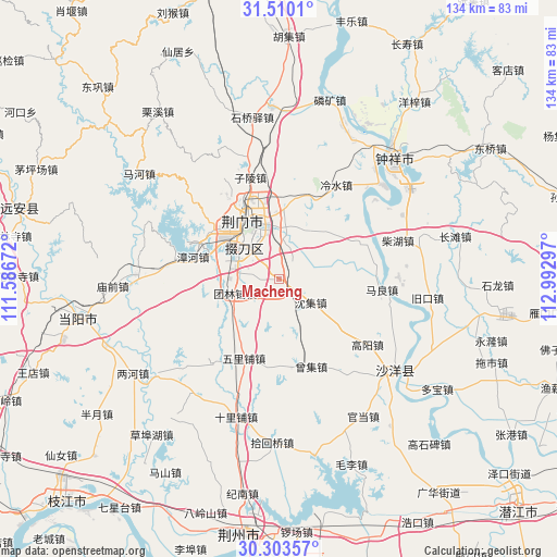
Macheng GPS coordinates[2]
30° 54' 31.464" North, 112° 17' 23.424" East
| Map corner | latitude | longitude |
|---|---|---|
| Upper-left | 31.5101°, | 111.58672° |
| Center: | 30.90874°, | 112.28984° |
| Lower-right: | 30.30357°, | 112.99297° |
| Map W x H: | 134.2×134.2 km | = 83.4×83.4mi |
| max Lat: | 53.31946° ⇑46.1% North |
| Macheng: | 30.90874° |
| min Lat: | ⇓53.9% South 18.22056° |
| min Long | Macheng | max Long |
| 75.07348° | 112.28984° | 134.28917° |
| W 38.8%⇐ | ⇒61.2% E |
Elevation
Elevation of Macheng is 70 m = 230 ft, and this is 414.8 m = 1361 ft below average elevation for this country.
| Max E: |
5622 m = 18445 ft | 65.6% |
| Avg. | 484.8 m = 1591 ft | |
| Macheng | 70 m = 230 ft | |
Min E: |
-3 m = -10 ft | 34.4% |
See also: China elevation on elevation.city.
Geographical zone
Macheng is located in North temperate zone (between Tropic of Cancer and the Arctic Circle). Distance of this Northern Tropic circle is 830.8 km =516.2 mi to South.| Distance of | km | miles | from Macheng |
|---|---|---|---|
| North Pole | 6570.3 | 4082.6 | to North |
| Arctic Circle | 3964.4 | 2463.4 | to North |
| Tropic Cancer | 830.8 | 516.2 | to South |
| Equator | 3436.7 | 2135.5 | to South |


Nearby cities:
15 places around Macheng: (largest is in red/bold)
• Baimiao
15.5 km =9.6 mi,  334°
334°
• Chaihu
30.1 km =18.7 mi,  72°
72°
• Duodaoshi
11.6 km =7.2 mi,  300°
300°
• Gaoyang
26.5 km =16.5 mi,  126°
126°
• Jingmen
16.1 km =10 mi, 329°
• Lengshui
26.5 km =16.5 mi,  31°
31°
• Maliang
24.8 km =15.4 mi,  95°
95°
• Pailou
16.2 km =10.1 mi,  357°
357°
• Shenji
9.4 km =5.8 mi, 127°
• Shipai
21.9 km =13.6 mi, 66°
• Tuanlinpu
11.4 km =7.1 mi,  251°
251°
• Wulipu
20.9 km =13 mi,  204°
204°
• Zengji
22.3 km =13.9 mi,  159°
159°
• Zhanghe
21.6 km =13.4 mi,  284°
284°
• Zilingpu
25.7 km =16 mi,  344°
344°
Sources, notices
• [Note1] Compared only with cities in China existing in our database
• [Src1] Map data: © OpenStreetMap contributors (CC-BY-SA)
• [Src2] Other city data from geonames.org with taken over terms of usage.
• [Src3] Geographical zone / Annual Mean Temperature by Robert A. Rohde @ Wikipedia
