Chaihu geodata
Chaihu (Hubei) is a seat of a fourth-order administrative division; located in China in Asia/Shanghai (GMT+8) time zone. In our database, there are 1268 cities with bigger population. Compared to other cities in China, 54.8% of cities are located further ↓South; 59.6% of cities are located further →East and 73% of cities have higher elevation than Chaihu. Note1


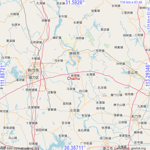
Chaihu GPS coordinates[2]
30° 59' 30.336" North, 112° 35' 25.188" East
| Map corner | latitude | longitude |
|---|---|---|
| Upper-left | 31.5926°, | 111.88721° |
| Center: | 30.99176°, | 112.59033° |
| Lower-right: | 30.38711°, | 113.29346° |
| Map W x H: | 134×134 km | = 83.3×83.3mi |
| max Lat: | 53.31946° ⇑45.2% North |
| Chaihu: | 30.99176° |
| min Lat: | ⇓54.8% South 18.22056° |
| min Long | Chaihu | max Long |
| 75.07348° | 112.59033° | 134.28917° |
| W 40.4%⇐ | ⇒59.6% E |
Elevation
Elevation of Chaihu is 42 m = 138 ft, and this is 442.8 m = 1453 ft below average elevation for this country.
| Max E: |
5622 m = 18445 ft | 73% |
| Avg. | 484.8 m = 1591 ft | |
| Chaihu | 42 m = 138 ft | |
Min E: |
-3 m = -10 ft | 27% |
See also: China elevation on elevation.city.
Geographical zone
Chaihu is located in North temperate zone (between Tropic of Cancer and the Arctic Circle). Distance of this Northern Tropic circle is 840 km =522 mi to South.| Distance of | km | miles | from Chaihu |
|---|---|---|---|
| North Pole | 6561.1 | 4076.9 | to North |
| Arctic Circle | 3955.2 | 2457.6 | to North |
| Tropic Cancer | 840 | 522 | to South |
| Equator | 3446 | 2141.2 | to South |


Nearby cities:
15 places around Chaihu: (largest is in red/bold)
• Changtan
13.6 km =8.5 mi,  85°
85°
• Dongqiao
32.1 km =19.9 mi,  45°
45°
• Gaoyang
26.2 km =16.3 mi,  196°
196°
• Jiukou
15.9 km =9.9 mi,  152°
152°
• Lengshui
20 km =12.4 mi,  312°
312°
• Macheng
30.1 km =18.7 mi,  252°
252°
• Maliang
12.5 km =7.8 mi, 198°
• Pailou
30.2 km =18.8 mi,  283°
283°
• Shayang
31.4 km =19.5 mi,  180°
180°
• Shenji
25.9 km =16.1 mi,  234°
234°
• Shilong
26.3 km =16.3 mi,  114°
114°
• Shipai
8.5 km =5.3 mi,  265°
265°
• Wenji
19.5 km =12.1 mi,  342°
342°
• Yangzi
33.6 km =20.9 mi,  6°
6°
• Zhongxiang
19.4 km =12.1 mi,  357°
357°
Sources, notices
• [Note1] Compared only with cities in China existing in our database
• [Src1] Map data: © OpenStreetMap contributors (CC-BY-SA)
• [Src2] Other city data from geonames.org with taken over terms of usage.
• [Src3] Geographical zone / Annual Mean Temperature by Robert A. Rohde @ Wikipedia
