Lutian geodata
Lutian (Fujian) is a seat of a fourth-order administrative division; located in China in Asia/Shanghai (GMT+8) time zone. In our database, there are 1268 cities with bigger population. Compared to other cities in China, 86.3% of cities are located further ↑North; 69.9% of cities are located further ←West and 79.7% of cities have lower elevation than Lutian. Note1


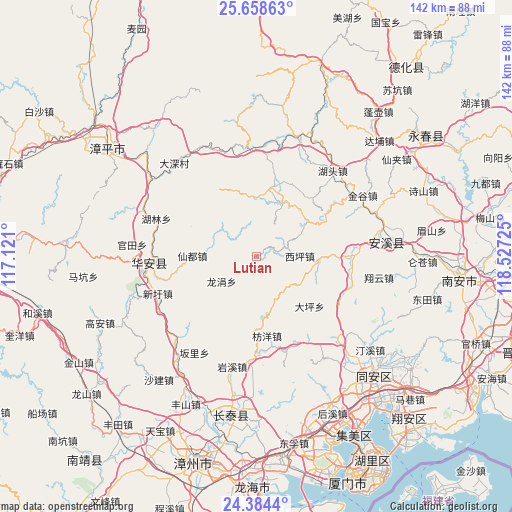
Lutian GPS coordinates[2]
25° 1' 23.412" North, 117° 49' 26.832" East
| Map corner | latitude | longitude |
|---|---|---|
| Upper-left | 25.65863°, | 117.121° |
| Center: | 25.02317°, | 117.82412° |
| Lower-right: | 24.3844°, | 118.52725° |
| Map W x H: | 141.7×141.7 km | = 88×88mi |
| max Lat: | 53.31946° ⇑86.3% North |
| Lutian: | 25.02317° |
| min Lat: | ⇓13.7% South 18.22056° |
| min Long | Lutian | max Long |
| 75.07348° | 117.82412° | 134.28917° |
| W 69.9%⇐ | ⇒30.1% E |
Elevation
Elevation of Lutian is 682 m = 2238 ft, and this is 197.2 m = 647 ft above average elevation for this country.
| Max E: |
5622 m = 18445 ft | 20.3% |
| Lutian | 682 m 2238 ft | |
| Avg. | 484.8 m = 1591 ft | |
Min E: |
-3 m = -10 ft | 79.7% |
See also: China elevation on elevation.city.
Geographical zone
Lutian is located in North temperate zone (between Tropic of Cancer and the Arctic Circle). Distance of this Northern Tropic circle is 176.4 km =109.6 mi to South.| Distance of | km | miles | from Lutian |
|---|---|---|---|
| North Pole | 7224.7 | 4489.2 | to North |
| Arctic Circle | 4618.9 | 2870.1 | to North |
| Tropic Cancer | 176.4 | 109.6 | to South |
| Equator | 2782.3 | 1728.8 | to South |


Nearby cities:
15 places around Lutian: (largest is in red/bold)
• Changkeng
19.7 km =12.2 mi,  12°
12°
• Gande
30.7 km =19.1 mi,  4°
4°
• Guanqiao
26.5 km =16.5 mi,  90°
90°
• Huafeng
30 km =18.6 mi,  265°
265°
• Hulin
29.6 km =18.4 mi,  290°
290°
• Huqiu
16.8 km =10.4 mi,  97°
97°
• Hushang
28.5 km =17.7 mi,  29°
29°
• Hutou
32.2 km =20 mi,  44°
44°
• Lantian
13.3 km =8.3 mi,  21°
21°
• Longmen
27.6 km =17.1 mi, 104°
• Penglai
29.5 km =18.3 mi,  65°
65°
• Shangqing
17.1 km =10.6 mi,  55°
55°
• Xiandu
17.7 km =11 mi, 270°
• Xianghua
20.4 km =12.7 mi,  333°
333°
• Xiping
11.7 km =7.3 mi, 88°
Sources, notices
• [Note1] Compared only with cities in China existing in our database
• [Src1] Map data: © OpenStreetMap contributors (CC-BY-SA)
• [Src2] Other city data from geonames.org with taken over terms of usage.
• [Src3] Geographical zone / Annual Mean Temperature by Robert A. Rohde @ Wikipedia
