Guanqiao geodata
Guanqiao (Fujian) is a seat of a fourth-order administrative division; located in China in Asia/Shanghai (GMT+8) time zone. In our database, there are 1268 cities with bigger population. Compared to other cities in China, 86.3% of cities are located further ↑North; 71% of cities are located further ←West and 59% of cities have higher elevation than Guanqiao. Note1


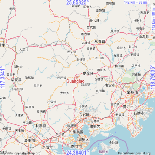
Guanqiao GPS coordinates[2]
25° 1' 22.008" North, 118° 5' 13.992" East
| Map corner | latitude | longitude |
|---|---|---|
| Upper-left | 25.65825°, | 117.3841° |
| Center: | 25.02278°, | 118.08722° |
| Lower-right: | 24.38401°, | 118.79035° |
| Map W x H: | 141.7×141.7 km | = 88×88mi |
| max Lat: | 53.31946° ⇑86.3% North |
| Guanqiao: | 25.02278° |
| min Lat: | ⇓13.7% South 18.22056° |
| min Long | Guanqiao | max Long |
| 75.07348° | 118.08722° | 134.28917° |
| W 71%⇐ | ⇒29% E |
Elevation
Elevation of Guanqiao is 104 m = 341 ft, and this is 380.8 m = 1249 ft below average elevation for this country.
| Max E: |
5622 m = 18445 ft | 59% |
| Avg. | 484.8 m = 1591 ft | |
| Guanqiao | 104 m = 341 ft | |
Min E: |
-3 m = -10 ft | 41% |
See also: China elevation on elevation.city.
Geographical zone
Guanqiao is located in North temperate zone (between Tropic of Cancer and the Arctic Circle). Distance of this Northern Tropic circle is 176.4 km =109.6 mi to South.| Distance of | km | miles | from Guanqiao |
|---|---|---|---|
| North Pole | 7224.8 | 4489.3 | to North |
| Arctic Circle | 4618.9 | 2870.1 | to North |
| Tropic Cancer | 176.4 | 109.6 | to South |
| Equator | 2782.3 | 1728.8 | to South |


Nearby cities:
15 places around Guanqiao: (largest is in red/bold)
• Cannei
14.1 km =8.8 mi,  67°
67°
• Chengxiang
10.6 km =6.6 mi,  76°
76°
• Fengcheng
10.4 km =6.5 mi, 68°
• Huqiu
10.1 km =6.3 mi,  257°
257°
• Jingu
16.9 km =10.5 mi,  9°
9°
• Kuidou
14.1 km =8.8 mi,  28°
28°
• Longmen
7 km =4.3 mi,  178°
178°
• Luncang
19.5 km =12.1 mi,  94°
94°
• Meishan
22.8 km =14.2 mi, 72°
• Penghua
22 km =13.7 mi, 29°
• Penglai
12.2 km =7.6 mi,  1°
1°
• Shangqing
15.7 km =9.8 mi,  307°
307°
• Xiangyun
9.3 km =5.8 mi,  127°
127°
• Xiping
14.8 km =9.2 mi,  271°
271°
• Yingdu
16.8 km =10.4 mi,  109°
109°
Sources, notices
• [Note1] Compared only with cities in China existing in our database
• [Src1] Map data: © OpenStreetMap contributors (CC-BY-SA)
• [Src2] Other city data from geonames.org with taken over terms of usage.
• [Src3] Geographical zone / Annual Mean Temperature by Robert A. Rohde @ Wikipedia
