Luoping geodata
Luoping (Jiangxi) is a seat of a fourth-order administrative division; located in China in Asia/Shanghai (GMT+8) time zone. In our database, there are 1268 cities with bigger population. Compared to other cities in China, 62.9% of cities are located further ↑North; 55.7% of cities are located further ←West and 58.6% of cities have higher elevation than Luoping. Note1


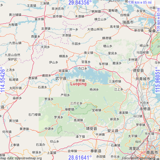
Luoping GPS coordinates[2]
29° 13' 54.552" North, 115° 15' 26.568" East
| Map corner | latitude | longitude |
|---|---|---|
| Upper-left | 29.84356°, | 114.55426° |
| Center: | 29.23182°, | 115.25738° |
| Lower-right: | 28.61641°, | 115.96051° |
| Map W x H: | 136.4×136.4 km | = 84.8×84.8mi |
| max Lat: | 53.31946° ⇑62.9% North |
| Luoping: | 29.23182° |
| min Lat: | ⇓37.1% South 18.22056° |
| min Long | Luoping | max Long |
| 75.07348° | 115.25738° | 134.28917° |
| W 55.7%⇐ | ⇒44.3% E |
Elevation
Elevation of Luoping is 107 m = 351 ft, and this is 377.8 m = 1240 ft below average elevation for this country.
| Max E: |
5622 m = 18445 ft | 58.6% |
| Avg. | 484.8 m = 1591 ft | |
| Luoping | 107 m = 351 ft | |
Min E: |
-3 m = -10 ft | 41.4% |
See also: China elevation on elevation.city.
Geographical zone
Luoping is located in North temperate zone (between Tropic of Cancer and the Arctic Circle). Distance of this Northern Tropic circle is 644.4 km =400.4 mi to South.| Distance of | km | miles | from Luoping |
|---|---|---|---|
| North Pole | 6756.8 | 4198.5 | to North |
| Arctic Circle | 4150.9 | 2579.2 | to North |
| Tropic Cancer | 644.4 | 400.4 | to South |
| Equator | 3250.3 | 2019.6 | to South |


Nearby cities:
15 places around Luoping: (largest is in red/bold)
• Baofeng
28.7 km =17.8 mi,  150°
150°
• Cengjia
23.8 km =14.8 mi,  188°
188°
• Cheqiao
24.4 km =15.2 mi,  53°
53°
• Futian
29.2 km =18.1 mi,  277°
277°
• Guanlian
16.8 km =10.4 mi,  18°
18°
• Henglu
24.9 km =15.5 mi,  324°
324°
• Luxi
22.7 km =14.1 mi,  354°
354°
• Nanyi
25 km =15.5 mi, 15°
• Sanzhaolun
19.2 km =11.9 mi, 190°
• Songxi
16.8 km =10.4 mi,  299°
299°
• Xinning
15.5 km =9.6 mi,  273°
273°
• Yangzhou
14.2 km =8.8 mi,  122°
122°
• Yanyang
17.9 km =11.1 mi,  226°
226°
• Zhelin
20.3 km =12.6 mi,  89°
89°
• Zhelin
24.3 km =15.1 mi,  95°
95°
Sources, notices
• [Note1] Compared only with cities in China existing in our database
• [Src1] Map data: © OpenStreetMap contributors (CC-BY-SA)
• [Src2] Other city data from geonames.org with taken over terms of usage.
• [Src3] Geographical zone / Annual Mean Temperature by Robert A. Rohde @ Wikipedia
