Cengjia geodata
Cengjia (Jiangxi) is a seat of a fourth-order administrative division; located in China in Asia/Shanghai (GMT+8) time zone. In our database, there are 1268 cities with bigger population. Compared to other cities in China, 65.2% of cities are located further ↑North; 55.5% of cities are located further ←West and 67.2% of cities have lower elevation than Cengjia. Note1


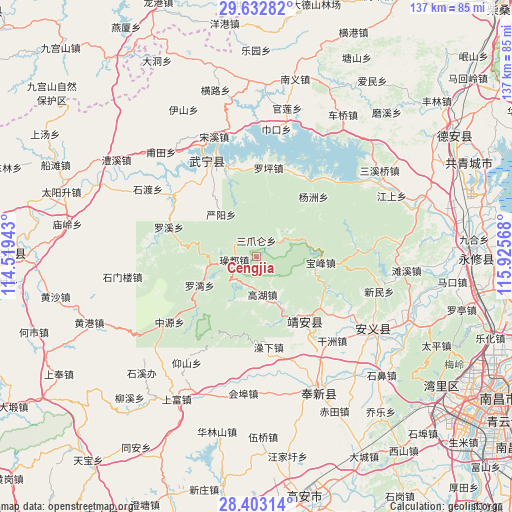
Cengjia GPS coordinates[2]
29° 1' 11.316" North, 115° 13' 21.18" East
| Map corner | latitude | longitude |
|---|---|---|
| Upper-left | 29.63282°, | 114.51943° |
| Center: | 29.01981°, | 115.22255° |
| Lower-right: | 28.40314°, | 115.92568° |
| Map W x H: | 136.7×136.7 km | = 84.9×84.9mi |
| max Lat: | 53.31946° ⇑65.2% North |
| Cengjia: | 29.01981° |
| min Lat: | ⇓34.8% South 18.22056° |
| min Long | Cengjia | max Long |
| 75.07348° | 115.22255° | 134.28917° |
| W 55.5%⇐ | ⇒44.5% E |
Elevation
Elevation of Cengjia is 362 m = 1188 ft, and this is 122.8 m = 403 ft below average elevation for this country.
| Max E: |
5622 m = 18445 ft | 32.8% |
| Avg. | 484.8 m = 1591 ft | |
| Cengjia | 362 m = 1188 ft | |
Min E: |
-3 m = -10 ft | 67.2% |
See also: China elevation on elevation.city.
Geographical zone
Cengjia is located in North temperate zone (between Tropic of Cancer and the Arctic Circle). Distance of this Northern Tropic circle is 620.8 km =385.7 mi to South.| Distance of | km | miles | from Cengjia |
|---|---|---|---|
| North Pole | 6780.4 | 4213.1 | to North |
| Arctic Circle | 4174.5 | 2593.9 | to North |
| Tropic Cancer | 620.8 | 385.7 | to South |
| Equator | 3226.7 | 2005 | to South |


Nearby cities:
15 places around Cengjia: (largest is in red/bold)
• Baofeng
17.5 km =10.9 mi,  94°
94°
• Ganzhou
30.3 km =18.8 mi,  137°
137°
• Gaohu
10.5 km =6.5 mi,  172°
172°
• Huibu
33 km =20.5 mi,  186°
186°
• Leigongjian
18.7 km =11.6 mi, 142°
• Luoping
23.8 km =14.8 mi,  8°
8°
• Luowan
17.1 km =10.6 mi,  241°
241°
• Luoxi
24.6 km =15.3 mi,  288°
288°
• Sanzhaolun
4.7 km =2.9 mi,  358°
358°
• Shuangxi
21.5 km =13.4 mi, 144°
• Shuikou
16.3 km =10.1 mi,  156°
156°
• Xinning
27.3 km =17 mi,  333°
333°
• Yangzhou
22.1 km =13.7 mi,  43°
43°
• Yanyang
14.7 km =9.1 mi,  319°
319°
• Zhongyuan
29 km =18 mi,  232°
232°
Sources, notices
• [Note1] Compared only with cities in China existing in our database
• [Src1] Map data: © OpenStreetMap contributors (CC-BY-SA)
• [Src2] Other city data from geonames.org with taken over terms of usage.
• [Src3] Geographical zone / Annual Mean Temperature by Robert A. Rohde @ Wikipedia
